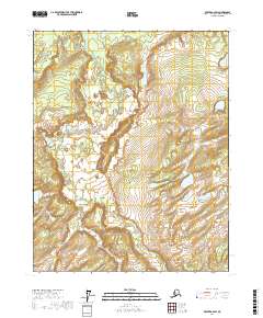
2017 Map of Beaver A-2 SW
USGS Topo · Published 2017About this map
Granite Cr and Butte Cr weave through the subarctic landscape of the Yukon-Koyukuk Census Area, illustrating the complex drainage systems of interior Alaska. This 2017 U.S. Geological Survey data captures a region defined by its vast water networks, including the prominent Beaver Lake and the meandering paths of Old Lost Cr and Lost Cr. The terrain is punctuated by significant landmarks like The Buttes Gap and Three Sleep Point, which provide crucial orientation in an area characterized by its lack of established roads or permanent settlements.
Find a feature on this map
11 named features on this map. Tap any name to fly to it.
Don’t see what you’re looking for? This feature index may not catch every label — zoom into the map to look around manually.
Map Details
Editions of this 2017 Beaver A-2 SW Map
This is the sole edition of this map. No revisions or reprints were ever made.
Other maps of this area

1945 · Livengood
USGS Topo · 1:250,000

1951 · Livengood
USGS Topo · 1:250,000

1951 · Beaver
USGS Topo · 1:250,000

1951 · Livengood D-3
USGS Topo · 1:63,360

1952 · Livengood D-2
USGS Topo · 1:63,360
1954 · Livengood D-2
USGS Topo · 1:63,360
1954 · Livengood D-3
USGS Topo · 1:63,360

1956 · Beaver A-3
USGS Topo · 1:63,360
1956 · Beaver A-2
USGS Topo · 1:63,360

1956 · Beaver
USGS Topo · 1:250,000