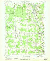
1959 Map of Beaver Center
USGS Topo · Published 1972About this map
Beaver Center and Springboro serve as the primary hubs in this rural landscape near the Ohio border, where the headwaters of several creeks carve through the Crawford County terrain. The region is defined by its water system, with Conneaut Creek winding through the northeast and the Middle Branch and East Branch Conneaut Creek draining the central fields. Industrial and transportation patterns are evident in the corridors of the Penn Central and Bessemer and Lake Erie railroads, which parallel the creek valleys to support local commerce.
Find a feature on this map
38 named features on this map. Tap any name to fly to it.
Don’t see what you’re looking for? This feature index may not catch every label — zoom into the map to look around manually.
Map Details
Editions of this 1959 Beaver Center Map
4 editions found

Other maps of this area

1900 · Girard
USGS Topo · 1:62,500

1905 · Andover
USGS Topo · 1:48,000

1906 · Conneaut
USGS Topo · 1:62,500

1906 · Linesville
USGS Topo · 1:62,500

1907 · Andover
USGS Topo · 1:62,500

1908 · Linesville
USGS Topo · 1:62,500

1950 · Cleveland
USGS Topo · 1:250,000

1956 · Cleveland
USGS Topo · 1:250,000

1959 · Conneautville
USGS Topo · 1:24,000

1959 · East Springfield
USGS Topo · 1:24,000