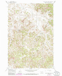
1966 Map of Beaver Creek School
USGS Topo · Published 1986About this map
Beaver Creek School stands as a focal point in this high-plains landscape, situated along the north-south drainage of Beaver Creek. The topography is defined by the expansive Custer National Forest and a series of deep draws and creeks that supported a dispersed ranching economy. This mid-century survey reveals an intricate network of water management features, including Main Ash Reservoir, Sawmill Reservoir, and several reservoirs along Deer Creek, alongside numerous named springs like Main Ash Spring and Cabin Creek Spring. These scattered water sources and wells, such as the Upper Deer Creek Well and Maxwell Well, indicate the essential infrastructure required for survival and livestock in the Powder River Basin. The rugged network of unimproved roads and fire breaks throughout Darling Draw and Sartin Draw underscores the isolation of the rural schoolhouses and private claims that once dotted this Montana cattle country.
Find a feature on this map
32 named features on this map. Tap any name to fly to it.
Don’t see what you’re looking for? This feature index may not catch every label — zoom into the map to look around manually.
Map Details
Editions of this 1966 Beaver Creek School Map
3 editions found

Other maps of this area

1954 · Hardin
USGS Topo · 1:250,000

1954 · Ekalaka
USGS Topo · 1:250,000

1956 · Ekalaka
USGS Topo · 1:250,000

1957 · Hardin
USGS Topo · 1:250,000

1958 · Ekalaka
USGS Topo · 1:250,000

1958 · Hardin
USGS Topo · 1:250,000

1965 · Ekalaka
USGS Topo · 1:250,000

1966 · Coleman Draw
USGS Topo · 1:24,000

1966 · Stacey
USGS Topo · 1:24,000

1966 · Home Creek Butte
USGS Topo · 1:24,000