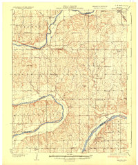
1936 Map of Belford
USGS Topo · Published 1936About this map
The Arkansas River meanders through this landscape on the edge of the Osage Nation, defining the borders of Kay, Noble, and Pawnee counties. In the mid-1930s, this region was a patchwork of small-scale rural infrastructure, characterized by an exceptionally high density of local school districts. Dozens of country schoolhouses, such as Pa He Sch, Spearhead Sch, and Belford Sch, served the dispersed farming and ranching communities between Apperson and the Bar L Ranch.
Find a feature on this map
46 named features on this map. Tap any name to fly to it.
Don’t see what you’re looking for? This feature index may not catch every label — zoom into the map to look around manually.
Map Details
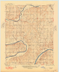
Editions of this 1936 Belford Map
3 editions found
Other maps of this area

1916 · Foraker
USGS Topo · 1:62,500

1929 · Skedee
USGS Topo · 1:62,500

1930 · Pawnee
USGS Topo · 1:62,500

1931 · Skedee
USGS Topo · 1:62,500

1932 · Fairfax
USGS Topo · 1:62,500

1935 · Kaw
USGS Topo · 1:62,500

1936 · Belford
USGS Topo · 1:62,500

1936 · Pawnee
USGS Topo · 1:62,500

1955 · Enid
USGS Topo · 1:250,000

1958 · Enid
USGS Topo · 1:250,000