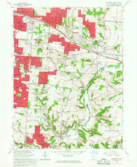
1965 Map of Bellbrook
USGS Topo · Published 1967About this map
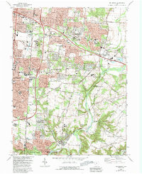
The Little Miami River divides this mid-1960s landscape between the Great Miami River Base and the Virginia Military District. The terrain transitions from the suburban expansion of Dayton and Kettering in the west to the more rural, rolling valley of Sugar Creek in the south. Local heritage is deeply etched into the map through features like the Pioneer Cem and the Covered Bridge near Washington Mills. Institutional landmarks such as Marianists College and the Dayton State Hospital Farm occupy significant acreage alongside the Walnut Grove Country Club. The presence of the Pennsylvania and Baltimore and Ohio railroad corridor through Alpha and Zimmerman highlights the region's historical transit backbone, while numerous educational sites like Bellbrook High Sch and Indian Riffle Jr High Sch reflect the mid-century growth of residential communities.
Find a feature on this map
57 named features on this map. Tap any name to fly to it.
Don’t see what you’re looking for? This feature index may not catch every label — zoom into the map to look around manually.
Map Details
Editions of this 1965 Bellbrook Map
5 editions found
Other maps of this area

1904 · Springfield
USGS Topo · 1:62,500

1904 · Dayton
USGS Topo · 1:62,500

1906 · Dayton
USGS Topo · 1:62,500

1906 · Springfield
USGS Topo · 1:62,500

1913 · Waynesville
USGS Topo · 1:62,500

1915 · Waynesville
USGS Topo · 1:62,500

1917 · Xenia
USGS Topo · 1:62,500

1947 · Columbus
USGS Topo · 1:250,000

1953 · Cincinnati
USGS Topo · 1:250,000

1955 · New Burlington
USGS Topo · 1:24,000