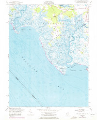
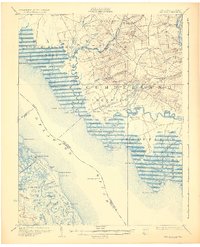
1956 Map of Ben Davis Point
USGS Topo · Published 1972About this map
Back Neck and the expansive marshes of Cumberland County define this coastal landscape as it was documented in the mid-1950s. The region is dominated by the winding path of the Cohansey River, which flows past Ragged Island and Tindall Island before emptying into Delaware Bay. The intricate network of tidal waterways includes Back Creek, Middle Marsh Creek, and Drumbo Creek, reflecting the importance of water access for this low-lying territory. Small settlements like Sea Breeze and Husted Landing are connected by narrow roads such as Sea Breeze Road, while isolated landmarks like the Cohansey Outer Lt (C) and the Tower (E) at Pier Point provide essential navigational aids. This survey reveals a traditional economy tied to the shoreline, from the oyster beds of Oyster Gut to the remote docks at Loyds Corner.
Find a feature on this map
53 named features on this map. Tap any name to fly to it.
Don’t see what you’re looking for? This feature index may not catch every label — zoom into the map to look around manually.
Map Details
Editions of this 1956 Ben Davis Point Map
4 editions found
Other maps of this area

1890 · Maurice Cove
USGS Topo · 1:62,500

1890 · Bay Side
USGS Topo · 1:62,500

1890 · Bridgeton
USGS Topo · 1:62,500

1891 · Maurice Cove
USGS Topo · 1:62,500

1894 · Bay Side
USGS Topo · 1:62,500

1894 · Bridgeton
USGS Topo · 1:62,500

1899 · Vineland
USGS Topo · 1:125,000

1919 · Vineland
USGS Topo · 1:125,000
1931 · Bay Side
USGS Topo · 1:62,500

1934 · Bowers
USGS Topo · 1:48,000
Featured Places
- Fairfield Township, NJ
- Hopewell Township, NJ
- Lawrence Township, NJ
- Greenwich Township, NJ
- Loyds Corner, Fairfield Township