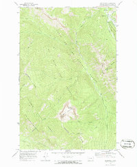
1970 Map of Benchmark
USGS Topo · Published 1986About this map
Lewis and Clark National Forest and the Bob Marshall Wilderness meet along the Continental Divide in this 1970 field-checked survey. The landscape is defined by the headwaters of the South Fork Sun River, where numerous seasonal creeks like Hoadley Creek and Ellis Creek descend from high ridges. The eastern edge of the map shows a rare pocket of infrastructure within the wilderness boundary, centered on the Benchmark Airfield and the Benchmark Work Center. This area serves as a gateway for the many pack trails that snake through the Sun River Game Preserve. High-altitude vantage points like Patrol Mountain and its Patrol Lookout stand over the basin, while the Wood Creek Hogback forms a distinctive geological barrier to the northeast. The presence of the Straight Cr Campground and Benchmark Campground suggests the area's mid-century importance as a base for backcountry exploration.
Find a feature on this map
30 named features on this map. Tap any name to fly to it.
Don’t see what you’re looking for? This feature index may not catch every label — zoom into the map to look around manually.
Map Details
Editions of this 1970 Benchmark Map
2 editions found
Other maps of this area

1902 · Ovando
USGS Topo · 1:125,000

1903 · Saypo
USGS Topo · 1:125,000

1903 · Coopers Lake
USGS Topo · 1:125,000

1905 · Ovando
USGS Topo · 1:125,000

1936 · Silvertip
USGS Topo · 1:96,000

1942 · Silvertip
USGS Topo · 1:125,000

1955 · Choteau
USGS Topo · 1:250,000

1957 · Choteau
USGS Topo · 1:250,000

1958 · Choteau
USGS Topo · 1:250,000

1958 · Pretty Prairie
USGS Topo · 1:24,000