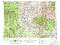
1955 Map of Bend
USGS Topo · Published 1973About this map
The High Desert and Cascade Range transition is meticulously detailed here, centered on the growing hub of Bend and the vast Warm Springs Indian Reservation. The hydrology of Central Oregon is a primary focus, illustrating the complex irrigation networks of the North Unit Main Canal and Pilot Butte Canal that transformed the arid plains around Madras and Redmond into productive agricultural land. The confluence of the Deschutes River, Metolius River, and Crooked River at Lake Billy Chinook highlights the significant recreational and hydroelectric development at The Cove Palisades State Park. To the west, the volcanic skyline of the Three Sisters, Mt Jefferson, and Mt Washington dominates the landscape, showing the early boundaries of the Three Sisters Wilderness Area. Rail history is preserved through the routes of the Oregon Trunk Ry and Union Pacific RR, which navigated the deep river canyons to reach isolated outposts like South Junction and Willowdale.
Find a feature on this map
219 named features on this map. Tap any name to fly to it.
Don’t see what you’re looking for? This feature index may not catch every label — zoom into the map to look around manually.
Map Details
Editions of this 1955 Bend Map
3 editions found

Other maps of this area

1916 · Estacada
USGS Topo · 1:125,000

1916 · Condon
USGS Topo · 1:125,000

1924 · Mount Hood
USGS Topo · 1:125,000

1925 · Waldo Lake
USGS Topo · 1:125,000

1926 · Mitchell
USGS Topo · 1:125,000

1926 · Bend
USGS Topo · 1:125,000

1927 · Mount Hood
USGS Topo · 1:125,000

1927 · Mt. Jefferson
USGS Topo · 1:125,000

1928 · Madras
USGS Topo · 1:125,000

1929 · Mill City
USGS Topo · 1:125,000