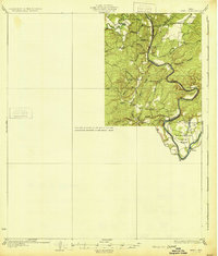
1931 Map of Bend
USGS Topo · Published 1931About this map
The Colorado River and San Saba River converge in a landscape defined by deep meanders and upland ridges along the border of San Saba Co and Lampasas Co. This 1920s-era topography reveals a rural Texas economy dependent on river crossings and rail access, centered around the settlement of Bend. The presence of numerous small educational institutions, including the Colony Sch and Cottonwood Sch, suggests a distributed population of farming families clustered near water sources like Antelope Creek and Rough Creek.
Find a feature on this map
35 named features on this map. Tap any name to fly to it.
Don’t see what you’re looking for? This feature index may not catch every label — zoom into the map to look around manually.
Map Details
Editions of this 1931 Bend Map
2 editions found

Other maps of this area

1885 · San Saba
USGS Topo · 1:125,000

1887 · Llano
USGS Topo · 1:125,000

1887 · Lampasas
USGS Topo · 1:125,000

1887 · Burnet
USGS Topo · 1:125,000

1893 · Burnet
USGS Topo · 1:125,000

1894 · Lampasas
USGS Topo · 1:125,000

1894 · San Saba
USGS Topo · 1:125,000

1894 · Llano
USGS Topo · 1:125,000

1903 · Burnet
USGS Topo · 1:125,000

1904 · Llano
USGS Topo · 1:125,000