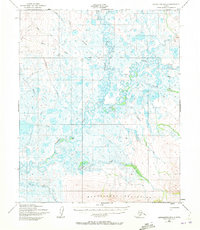
1950 Map of Bendeleben B-5
USGS Topo · Published 1972About this map
The Bendeleben Mountains anchor the southern edge of this 1950s landscape, their steep contours dropping away into a complex network of meandering Arctic waterways. This remote terrain is defined by the convergence of the Kuzitrin River and its major tributaries, including the Noxapaga River and Birch Creek. The hydrological pattern revealed here shows an intricate system of oxbows and marshlands typical of the Seward Peninsula, where the Kateel River Base Line serves as a primary surveying reference across the vast tundra.
Find a feature on this map
16 named features on this map. Tap any name to fly to it.
Don’t see what you’re looking for? This feature index may not catch every label — zoom into the map to look around manually.
Map Details
Editions of this 1950 Bendeleben B-5 Map
3 editions found
Other maps of this area

1950 · Bendeleben C-5
USGS Topo · 1:63,360

1950 · Bendeleben A-6
USGS Topo · 1:63,360

1950 · Bendeleben B-5
USGS Topo · 1:63,360

1950 · Bendeleben A-4
USGS Topo · 1:63,360

1950 · Bendeleben B-6
USGS Topo · 1:63,360

1950 · Bendeleben A-5
USGS Topo · 1:63,360

1950 · Bendeleben C-6
USGS Topo · 1:63,360

1950 · Bendeleben B-4
USGS Topo · 1:63,360

1950 · Bendeleben C-4
USGS Topo · 1:63,360

1950 · Bendeleben
USGS Topo · 1:250,000