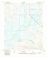
1950 Map of Bendeleben B-5
USGS Topo · Published 1982About this map
The Bering Land Bridge National Preserve dominates the northern reaches of this Alaskan interior landscape, where the wide, meandering channel of the Kuzitrin River cuts through an expanse of wetlands and low-relief tundra. To the south, the terrain rises sharply into the Bendeleben Mountains, a stark contrast to the water-saturated lowlands fed by the Noxapaga River and Bonanza Creek.
Find a feature on this map
19 named features on this map. Tap any name to fly to it.
Don’t see what you’re looking for? This feature index may not catch every label — zoom into the map to look around manually.
Map Details
Editions of this 1950 Bendeleben B-5 Map
3 editions found
Other maps of this area

1950 · Bendeleben C-5
USGS Topo · 1:63,360

1950 · Bendeleben A-6
USGS Topo · 1:63,360

1950 · Bendeleben B-5
USGS Topo · 1:63,360

1950 · Bendeleben A-4
USGS Topo · 1:63,360

1950 · Bendeleben B-6
USGS Topo · 1:63,360

1950 · Bendeleben A-5
USGS Topo · 1:63,360

1950 · Bendeleben C-6
USGS Topo · 1:63,360

1950 · Bendeleben B-4
USGS Topo · 1:63,360

1950 · Bendeleben C-4
USGS Topo · 1:63,360

1950 · Bendeleben
USGS Topo · 1:250,000