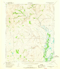
1950 Map of Bendeleben B-6
USGS Topo · Published 1967About this map
Placer Gold Mining Area sites dominate the drainage basins of Dahl Creek and Coffee Cr on this 1950s study of the Seward Peninsula. The landscape is a network of hydraulic activity and aviation, centered on the small settlements of Dahl and Kougarok. Remote outposts like the Roadhouse provided essential refuge along the Tractor Trail system, which served as the primary overland artery before modern infrastructure. The serpentine Kougarok River and Kuzitrin River provide the natural framework for the region's topography, winding past landmarks like Coffee Dome and Bunker Hill. Aviation infrastructure, critical for these isolated mining districts, is represented by the Kougarok Landing Strip and Dahl Landing Strip. The presence of labels like Brakes Bottom and Checkers reflects the local vernacular of the miners and trappers who inhabited this territory during the mid-century gold era.
Find a feature on this map
44 named features on this map. Tap any name to fly to it.
Don’t see what you’re looking for? This feature index may not catch every label — zoom into the map to look around manually.
Map Details
Editions of this 1950 Bendeleben B-6 Map
3 editions found
Other maps of this area

1950 · Bendeleben C-5
USGS Topo · 1:63,360

1950 · Bendeleben A-6
USGS Topo · 1:63,360

1950 · Bendeleben B-5
USGS Topo · 1:63,360

1950 · Bendeleben B-6
USGS Topo · 1:63,360

1950 · Bendeleben A-5
USGS Topo · 1:63,360

1950 · Bendeleben C-6
USGS Topo · 1:63,360

1950 · Teller
USGS Topo · 1:250,000

1950 · Bendeleben
USGS Topo · 1:250,000

1950 · Teller A-1
USGS Topo · 1:63,360

1950 · Teller B-1
USGS Topo · 1:63,360