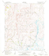
1950 Map of Bendeleben C-5
USGS Topo · Published 1972About this map
North Fork Kougarok River defines the drainage of this interior landscape, where a web of gold-bearing watercourses like Skookum Creek and Humboldt Creek once drove prospectors into the remote Seward Peninsula. The 1950 topography reveals the infrastructure of a fading mining era, most notably the Noxapaga Landing Strip (Abandoned) and the Rainbow Camp Landing Strip, which provided vital air access to isolated claims. A series of Tractor Trail segments cut across the high ridges, connecting various drainages such as Lincoln Creek and Winona Creek. These overland routes and primitive landing fields illustrate the transition from traditional mining methods to more mobile, modern prospecting operations in the mid-20th century, before many of these sites were ultimately left to the elements.
Find a feature on this map
37 named features on this map. Tap any name to fly to it.
Don’t see what you’re looking for? This feature index may not catch every label — zoom into the map to look around manually.
Map Details
Editions of this 1950 Bendeleben C-5 Map
3 editions found
Other maps of this area

1950 · Bendeleben C-5
USGS Topo · 1:63,360

1950 · Bendeleben B-5
USGS Topo · 1:63,360

1950 · Bendeleben B-6
USGS Topo · 1:63,360

1950 · Bendeleben C-6
USGS Topo · 1:63,360

1950 · Bendeleben B-4
USGS Topo · 1:63,360

1950 · Bendeleben C-4
USGS Topo · 1:63,360

1950 · Bendeleben D-6
USGS Topo · 1:63,360

1950 · Bendeleben D-5
USGS Topo · 1:63,360

1950 · Bendeleben
USGS Topo · 1:250,000

1950 · Bendeleben D-4
USGS Topo · 1:63,360