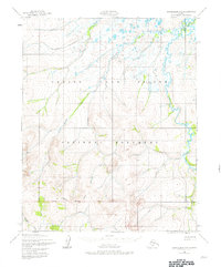
1950 Map of Bendeleben D-5
USGS Topo · Published 1980About this map
The Bering Land Bridge National Monument dominates this mid-century survey of the Seward Peninsula, revealing a landscape defined by its remote drainage systems and high ridges. The Continental Divide cuts across the southern portion of the map, separating the headwaters of Midnight Creek and Taylor Creek from the northward-flowing waters of Humbolt Creek and the Pish River. Human activity is sparse in this subarctic terrain, indicated primarily by the Ballarat mine site and an isolated Cabin located near the western boundary. A complex network of waterways, including Moonlight Creek and the Goodhope River, illustrates the hydrologic patterns of the region prior to any significant modern development. The mapping, based on 1950 aerial photography, provides a detailed look at the tundra and highlands as they existed before the area received its formal monument designation.
Find a feature on this map
13 named features on this map. Tap any name to fly to it.
Don’t see what you’re looking for? This feature index may not catch every label — zoom into the map to look around manually.
Map Details
Editions of this 1950 Bendeleben D-5 Map
3 editions found
Other maps of this area

1950 · Bendeleben C-5
USGS Topo · 1:63,360

1950 · Bendeleben C-6
USGS Topo · 1:63,360

1950 · Bendeleben C-4
USGS Topo · 1:63,360

1950 · Bendeleben D-6
USGS Topo · 1:63,360

1950 · Bendeleben D-5
USGS Topo · 1:63,360

1950 · Bendeleben
USGS Topo · 1:250,000

1950 · Bendeleben D-4
USGS Topo · 1:63,360

1950 · Kotzebue A-6
USGS Topo · 1:63,360

1950 · Kotzebue A-4
USGS Topo · 1:63,360

1950 · Kotzebue A-5
USGS Topo · 1:63,360