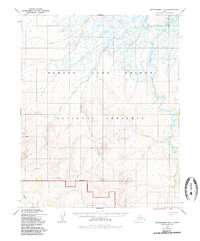
1950 Map of Bendeleben D-5
USGS Topo · Published 1985About this map
The Continental Divide winds through this remote stretch of the Seward Peninsula, a landscape defined by the drainage basins of the Goodhope River and the Kugruk River. Based on photogrammetric methods from 1950, the map documents the transition of this arctic wilderness into the Bering Land Bridge National Preserve. The terrain is characterized by a dense network of waterways, including Humboldt Creek, Ballarat Creek, and Little Daisy Creek, which carve through the high elevations. A solitary Cabin stands as a rare sign of human habitation in the western interior, while the southern margin shows the headwaters of Taylor Creek and Midnight Creek. This survey captures the region's geography prior to the formal establishment of current federal reservation boundaries, offering a precise look at the hydrology and relief of the Alaskan bush during the mid-20th century.
Find a feature on this map
13 named features on this map. Tap any name to fly to it.
Don’t see what you’re looking for? This feature index may not catch every label — zoom into the map to look around manually.
Map Details
Editions of this 1950 Bendeleben D-5 Map
3 editions found
Other maps of this area

1950 · Bendeleben C-5
USGS Topo · 1:63,360

1950 · Bendeleben C-6
USGS Topo · 1:63,360

1950 · Bendeleben C-4
USGS Topo · 1:63,360

1950 · Bendeleben D-6
USGS Topo · 1:63,360

1950 · Bendeleben D-5
USGS Topo · 1:63,360

1950 · Bendeleben
USGS Topo · 1:250,000

1950 · Bendeleben D-4
USGS Topo · 1:63,360

1950 · Kotzebue A-6
USGS Topo · 1:63,360

1950 · Kotzebue A-4
USGS Topo · 1:63,360

1950 · Kotzebue A-5
USGS Topo · 1:63,360