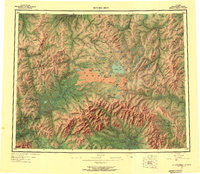
1950 Map of Bendeleben
USGS Topo · Published 1956About this map
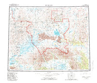
The Seward Peninsula interior is dominated here by the towering Mount Bendeleben and an extensive field of volcanic features. A sprawling lava bed across the central landscape is punctuated by distinct formations such as Lost Jim Cone, Andromeda Cone, and the Twin Calderas. This 1950s-era survey documents a landscape where remote outposts like Taylor and Aurora are connected by a network of tractor trails rather than established highways. This pattern of infrastructure suggests a region still heavily reliant on seasonal mining and transit, as evidenced by the Gold Mines near the Inmachuk River and specialized points like Bunker Hill Station and Camp 19. The map also captures the vast drainage systems of the Kuzitrin River and Fish River, which fed the regional economy during this mid-century period.
Find a feature on this map
119 named features on this map. Tap any name to fly to it.
Don’t see what you’re looking for? This feature index may not catch every label — zoom into the map to look around manually.
Map Details
Editions of this 1950 Bendeleben Map
6 editions found

Other maps of this area

1907 · Casadepaga
USGS Topo · 1:62,500

1948 · Norton Bay
USGS Topo · 1:250,000

1950 · Kotzebue A-1
USGS Topo · 1:63,360

1950 · Bendeleben C-5
USGS Topo · 1:63,360

1950 · Bendeleben A-6
USGS Topo · 1:63,360

1950 · Bendeleben B-5
USGS Topo · 1:63,360

1950 · Bendeleben A-4
USGS Topo · 1:63,360

1950 · Bendeleben C-1
USGS Topo · 1:63,360

1950 · Bendeleben C-3
USGS Topo · 1:63,360

1950 · Bendeleben B-6
USGS Topo · 1:63,360