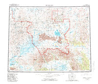
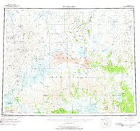
1950 Map of Bendeleben
USGS Topo · Published 1982About this map
The Seward Peninsula interior is revealed here in the mid-20th century, showing a remote landscape shaped by mineral extraction and geothermal activity. The Bering Land Bridge National Preserve dominates the central terrain, while industrial history is evidenced by the Chicago Creek Coal Mines in the northeast and the Seward Peninsula RR corridor. Localized centers like Serpentine Hot Springs and Pilgrim Springs provide notable landmarks for both landing aircraft and natural geothermal features.
Find a feature on this map
57 named features on this map. Tap any name to fly to it.
Don’t see what you’re looking for? This feature index may not catch every label — zoom into the map to look around manually.
Map Details
Editions of this 1950 Bendeleben Map
6 editions found

Other maps of this area

1907 · Casadepaga
USGS Topo · 1:62,500

1948 · Norton Bay
USGS Topo · 1:250,000

1950 · Kotzebue A-1
USGS Topo · 1:63,360

1950 · Bendeleben C-5
USGS Topo · 1:63,360

1950 · Bendeleben A-6
USGS Topo · 1:63,360

1950 · Bendeleben B-5
USGS Topo · 1:63,360

1950 · Bendeleben A-4
USGS Topo · 1:63,360

1950 · Bendeleben C-1
USGS Topo · 1:63,360

1950 · Bendeleben C-3
USGS Topo · 1:63,360

1950 · Bendeleben B-6
USGS Topo · 1:63,360