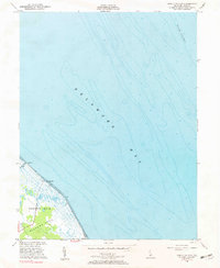
1956 Map of Bennetts Pier
USGS Topo · Published 1957About this map
Delaware Bay dominates this mid-century hydrographic and topographic study, where the shifting shoreline of Milford Neck meets the deep waters of Blake Channel. Centered on Bennetts Pier, the map illustrates a sparse coastal landscape defined by tidal marshes and small drainage channels like Brockonbridge Gut. The inland portion, designated as District No 10, shows a transition from wooded wetlands to more defined agricultural plots, connected by unimproved roads that terminate at the shore. This 1956 revision reflects the area's character before modern coastal development, preserving the positions of local landmarks like Sandy Pt and Clark Pt. Further south, the map captures the beginning of Big Stone Beach, providing a detailed record of the Delaware coastline's bathymetry and topography during the post-war era.
Find a feature on this map
9 named features on this map. Tap any name to fly to it.
Don’t see what you’re looking for? This feature index may not catch every label — zoom into the map to look around manually.
Map Details
Editions of this 1956 Bennetts Pier Map
2 editions found
Other maps of this area

1890 · Maurice Cove
USGS Topo · 1:62,500

1891 · Maurice Cove
USGS Topo · 1:62,500

1899 · Vineland
USGS Topo · 1:125,000

1918 · Cedar Creek
USGS Topo · 1:62,500

1918 · Cape Henlopen
USGS Topo · 1:62,500

1919 · Cedar Creek
USGS Topo · 1:62,500

1919 · Vineland
USGS Topo · 1:125,000

1934 · Bowers
USGS Topo · 1:48,000
1936 · Bowers
USGS Topo · 1:62,500

1937 · Cape Henlopen
USGS Topo · 1:62,500