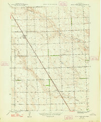
1948 Map of Berea Creek West
USGS Topo · Published 1948About this map
Berea serves as a central hub for this portion of the High Plains, situated along the Chicago Burlington and Quincy railroad line. The settlement pattern follows the rail corridor, which cuts diagonally across the township lines, punctuated by infrastructure like Yale Siding. This 1946 survey, published in 1948, illustrates a landscape defined by sparse water sources and agricultural development, where several Windmills are specifically noted as critical landmarks for water access. The rural educational system is represented by School No 12 and School No 45, which were positioned to serve the outlying farmsteads between the seasonal flows of Hemingford Creek and the North Fork Berea Creek. The drainage of Berea Creek further shapes the terrain, revealing the essential relationship between the railroad's path and the available water for livestock and local homesteads.
Find a feature on this map
13 named features on this map. Tap any name to fly to it.
Don’t see what you’re looking for? This feature index may not catch every label — zoom into the map to look around manually.
Map Details
Editions of this 1948 Berea Creek West Map
2 editions found
Other maps of this area

1946 · Berea Creek East
USGS Topo · 1:24,000

1947 · Alliance
USGS Topo · 1:24,000

1947 · Bronco Lake
USGS Topo · 1:24,000

1947 · Box Butte
USGS Topo · 1:24,000

1948 · Hemingford
USGS Topo · 1:24,000

1948 · Hemingford 4 SE
USGS Topo · 1:24,000

1948 · Berea Creek West
USGS Topo · 1:24,000

1948 · Berea Creek East
USGS Topo · 1:24,000

1948 · Hemingford 4 NE
USGS Topo · 1:24,000

1948 · Alliance
USGS Topo · 1:24,000