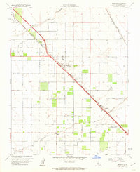
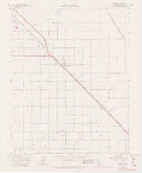
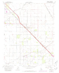
1961 Map of Berenda
USGS Topo · Published 1962About this map
Fairmead and Berenda center this early 1960s survey of Madera County, where the agricultural grid of the San Joaquin Valley is defined by complex irrigation and heavy rail infrastructure. The landscape is dominated by the dual lines of the Southern Pacific and the Atchison Topeka and Santa Fe railroads, which parallel the major thoroughfares of Chowchilla Boulevard and Fairmead Boulevard. A network of water management features, including the Berenda Slough and multiple laterals like Califa Lateral A, supports the orchards and fields that dominate the terrain.
Find a feature on this map
21 named features on this map. Tap any name to fly to it.
Don’t see what you’re looking for? This feature index may not catch every label — zoom into the map to look around manually.
Map Details
Editions of this 1961 Berenda Map
4 editions found
Historical Maps of Madera Through Time
220 maps found

1901 Mt. Lyell
Madera County, CA

1916 Berenda
Madera County, CA

1916 Sulphur Springs
Madera County, CA

1918 Berenda
Madera County, CA

1918 Bliss Ranch
Madera County, CA

1919 Little Table Mountain
Madera County, CA

1919 Raynor Creek
Madera County, CA

1919 Sulphur Springs
Madera County, CA

1920 Bonita Ranch
Madera County, CA

1920 Kismet
Madera County, CA

1921 Bonita Ranch
Madera County, CA

1921 Daulton
Madera County, CA

1922 Gregg
Madera County, CA

1922 Kentucky Well
Madera County, CA

1922 Lanes Bridge
Madera County, CA

1922 Pozo Farm
Madera County, CA

1924 Gravelly Ford
Madera County, CA

1942 Daulton
Madera County, CA

1942 Little Table Mountain
Madera County, CA

1942 Millerton Lake
Madera County, CA

1942 Raymond
Madera County, CA

1944 Raymond
Madera County, CA

1945 Millerton Lake
Madera County, CA

1946 Bonita Ranch
Madera County, CA

1946 Gravelly Ford
Madera County, CA

1946 Gregg
Madera County, CA

1946 Lanes Bridge
Madera County, CA

1947 Bonita Ranch
Madera County, CA

1947 Gravelly Ford
Madera County, CA

1947 Gregg
Madera County, CA

1947 Horsecamp Mountain
Madera County, CA

1947 Lanes Bridge
Madera County, CA

1947 Pozo Farm
Madera County, CA

1947 Raynor Creek
Madera County, CA

1948 Berenda
Madera County, CA

1948 Bliss Ranch
Madera County, CA

1948 Horsecamp Mountain
Madera County, CA

1948 Kentucky Well
Madera County, CA

1948 Kismet
Madera County, CA

1953 Devils Postpile
Madera County, CA

1953 Merced Peak
Madera County, CA

1953 Shuteye Peak
Madera County, CA

1956 Mendota Dam
Madera County, CA

1960 Bliss Ranch
Madera County, CA

1961 Berenda
Madera County, CA

1961 Firebaugh NE
Madera County, CA

1961 Kismet
Madera County, CA

1961 Raynor Creek
Madera County, CA

1962 Daulton
Madera County, CA

1962 Knowles
Madera County, CA

1962 Little Table Mountain
Madera County, CA

1962 Poso Farm
Madera County, CA

1962 Raymond
Madera County, CA

1962 Raymond
Madera County, CA

1963 Bonita Ranch
Madera County, CA

1963 Gravelly Ford
Madera County, CA

1964 Lanes Bridge
Madera County, CA

1965 Gregg
Madera County, CA

1965 Herndon
Madera County, CA

1965 Millerton Lake
Madera County, CA

1965 Millerton Lake West
Madera County, CA

1965 O'Neals
Madera County, CA

1982 Balloon Dome
Madera County, CA

1982 Cascadel Point
Madera County, CA

1983 Cattle Mtn
Madera County, CA

1983 Mt. Ritter
Madera County, CA

1984 Crystal Crag
Madera County, CA

1990 Little Shuteye Peak
Madera County, CA

1990 Mammoth Pool Dam
Madera County, CA

1990 Mount Lyell
Madera County, CA

1990 Shuteye Peak
Madera County, CA

1990 Sing Peak
Madera County, CA

1990 Squaw Dome
Madera County, CA

1990 Timber Knob
Madera County, CA

1990 White Chief Mountain
Madera County, CA

1992 Cattle Mtn
Madera County, CA

1992 Crystal Crag
Madera County, CA

1992 Mount Lyell
Madera County, CA

1992 Mt. Ritter
Madera County, CA

1992 Sing Peak
Madera County, CA

1992 Timber Knob
Madera County, CA

1993 Cascadel Point
Madera County, CA

1994 Crystal Crag
Madera County, CA

1999 Raynor Creek
Madera County, CA

2004 Balloon Dome
Madera County, CA

2004 Cascadel Point
Madera County, CA

2004 Cattle Mountain
Madera County, CA

2004 Little Shuteye Peak
Madera County, CA

2004 Mammoth Pool Dam
Madera County, CA

2004 Mount Lyell
Madera County, CA

2004 Mt. Ritter
Madera County, CA

2004 Piyau Dome
Madera County, CA

2004 Shuteye Peak
Madera County, CA

2004 Sing Peak
Madera County, CA

2004 Timber Knob
Madera County, CA

2004 White Chief Mountain
Madera County, CA

2012 Balloon Dome
Madera County, CA

2012 Berenda
Madera County, CA

2012 Bliss Ranch
Madera County, CA

2012 Bonita Ranch
Madera County, CA

2012 Cascadel Point
Madera County, CA

2012 Cattle Mountain
Madera County, CA

2012 Crystal Crag
Madera County, CA

2012 Daulton
Madera County, CA

2012 Firebaugh NE
Madera County, CA

2012 Gravelly Ford
Madera County, CA

2012 Gregg
Madera County, CA

2012 Horsecamp Mountain
Madera County, CA

2012 Kismet
Madera County, CA

2012 Knowles
Madera County, CA

2012 Lanes Bridge
Madera County, CA

2012 Little Shuteye Peak
Madera County, CA

2012 Little Table Mountain
Madera County, CA

2012 Mammoth Pool Dam
Madera County, CA

2012 Mendota Dam
Madera County, CA

2012 Millerton Lake West
Madera County, CA

2012 Mount Lyell
Madera County, CA

2012 Mount Ritter
Madera County, CA

2012 O'Neals
Madera County, CA

2012 Piyau Dome
Madera County, CA

2012 Poso Farm
Madera County, CA

2012 Raymond
Madera County, CA

2012 Raynor Creek
Madera County, CA

2012 Shuteye Peak
Madera County, CA

2012 Sing Peak
Madera County, CA

2012 Timber Knob
Madera County, CA

2012 White Chief Mountain
Madera County, CA

2015 Balloon Dome
Madera County, CA

2015 Berenda
Madera County, CA

2015 Bliss Ranch
Madera County, CA

2015 Bonita Ranch
Madera County, CA

2015 Cascadel Point
Madera County, CA

2015 Cattle Mountain
Madera County, CA

2015 Crystal Crag
Madera County, CA

2015 Daulton
Madera County, CA

2015 Firebaugh NE
Madera County, CA

2015 Gravelly Ford
Madera County, CA

2015 Gregg
Madera County, CA

2015 Horsecamp Mountain
Madera County, CA

2015 Kismet
Madera County, CA

2015 Knowles
Madera County, CA

2015 Lanes Bridge
Madera County, CA

2015 Little Shuteye Peak
Madera County, CA

2015 Little Table Mountain
Madera County, CA

2015 Mammoth Pool Dam
Madera County, CA

2015 Mendota Dam
Madera County, CA

2015 Millerton Lake West
Madera County, CA

2015 Mount Lyell
Madera County, CA

2015 Mount Ritter
Madera County, CA

2015 O'Neals
Madera County, CA

2015 Piyau Dome
Madera County, CA

2015 Poso Farm
Madera County, CA

2015 Raymond
Madera County, CA

2015 Raynor Creek
Madera County, CA

2015 Shuteye Peak
Madera County, CA

2015 Sing Peak
Madera County, CA

2015 Timber Knob
Madera County, CA

2015 White Chief Mountain
Madera County, CA

2018 Balloon Dome
Madera County, CA

2018 Berenda
Madera County, CA

2018 Bliss Ranch
Madera County, CA

2018 Bonita Ranch
Madera County, CA

2018 Cascadel Point
Madera County, CA

2018 Cattle Mountain
Madera County, CA

2018 Crystal Crag
Madera County, CA

2018 Daulton
Madera County, CA

2018 Firebaugh NE
Madera County, CA

2018 Gravelly Ford
Madera County, CA

2018 Gregg
Madera County, CA

2018 Horsecamp Mountain
Madera County, CA

2018 Kismet
Madera County, CA

2018 Knowles
Madera County, CA

2018 Lanes Bridge
Madera County, CA

2018 Little Shuteye Peak
Madera County, CA

2018 Little Table Mountain
Madera County, CA

2018 Mammoth Pool Dam
Madera County, CA

2018 Mendota Dam
Madera County, CA

2018 Millerton Lake West
Madera County, CA

2018 Mount Lyell
Madera County, CA

2018 Mount Ritter
Madera County, CA

2018 O'Neals
Madera County, CA

2018 Piyau Dome
Madera County, CA

2018 Poso Farm
Madera County, CA

2018 Raymond
Madera County, CA

2018 Raynor Creek
Madera County, CA

2018 Shuteye Peak
Madera County, CA

2018 Sing Peak
Madera County, CA

2018 Timber Knob
Madera County, CA

2018 White Chief Mountain
Madera County, CA

2021 Balloon Dome
Madera County, CA

2021 Berenda
Madera County, CA

2021 Bonita Ranch
Madera County, CA

2021 Cascadel Point
Madera County, CA

2021 Cattle Mountain
Madera County, CA

2021 Crystal Crag
Madera County, CA

2021 Daulton
Madera County, CA

2021 Firebaugh NE
Madera County, CA

2021 Gravelly Ford
Madera County, CA

2021 Gregg
Madera County, CA

2021 Horsecamp Mountain
Madera County, CA

2021 Kismet
Madera County, CA

2021 Knowles
Madera County, CA

2021 Lanes Bridge
Madera County, CA

2021 Little Shuteye Peak
Madera County, CA

2021 Little Table Mountain
Madera County, CA

2021 Mammoth Pool Dam
Madera County, CA

2021 Mendota Dam
Madera County, CA

2021 Millerton Lake West
Madera County, CA

2021 Mount Lyell
Madera County, CA

2021 Mount Ritter
Madera County, CA

2021 O'Neals
Madera County, CA

2021 Piyau Dome
Madera County, CA

2021 Poso Farm
Madera County, CA

2021 Raymond
Madera County, CA

2021 Raynor Creek
Madera County, CA

2021 Shuteye Peak
Madera County, CA

2021 Sing Peak
Madera County, CA

2021 Timber Knob
Madera County, CA

2021 White Chief Mountain
Madera County, CA

2022 Bliss Ranch
Madera County, CA