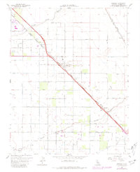
1961 Map of Berenda
USGS Topo · Published 1981About this map
The Southern Pacific and Atchison Topeka and Santa Fe railroads anchor this San Joaquin Valley landscape, following parallel paths through the communities of Fairmead, Berenda, and Sharon. The mapping, updated with 1981 revisions, reveals a complex agricultural network of canals and laterals, including Califa Lateral A and the Aqueduct, which support the grid-based development of numbered avenues. Local social and civic life is centered around landmarks like the Dixieland School, Grange Hall, and the County Fairgrounds, illustrating the region's mid-century transition as small settlements supported the irrigation-heavy farming economy.
Find a feature on this map
41 named features on this map. Tap any name to fly to it.
Don’t see what you’re looking for? This feature index may not catch every label — zoom into the map to look around manually.
Map Details
Editions of this 1961 Berenda Map
4 editions found
Other maps of this area

1916 · Berenda
USGS Topo · 1:31,680

1918 · Chowchilla
USGS Topo · 1:31,680

1918 · Berenda
USGS Topo · 1:31,680

1918 · La Grand
USGS Topo · 1:31,680

1919 · Plainsberg
USGS Topo · 1:31,680

1919 · Raynor Creek
USGS Topo · 1:31,680

1920 · Kismet
USGS Topo · 1:31,680

1920 · Bonita Ranch
USGS Topo · 1:31,680

1921 · Bonita Ranch
USGS Topo · 1:31,680

1922 · Kentucky Well
USGS Topo · 1:31,680