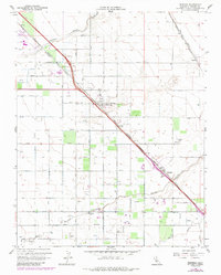
1961 Map of Berenda
USGS Topo · Published 1987About this map
The agricultural landscape of Madera County is defined here by a network of irrigation and transportation, including the Califa Canal and numerous laterals like Califa Lateral A. The parallel paths of Fairmead Boulevard and the Southern Pacific railroad corridor anchor the settlement of Fairmead, which shows significant development alongside the County Fairgrounds. To the southeast, the small rail siding of Berenda sits near the crossing of Berenda Creek, while Sharon is positioned along the Atchison Topeka and Santa Fe line in the northeast. This 1961 survey, later updated in 1987, reveals the rural infrastructure essential to the Central Valley, from the Dixieland Sch and Grange Hall to specialized features like Storage Bins and a Weather Station. The drainage patterns of Slough and Dry Creek illustrate the natural hydrology that local water projects sought to manage.
Find a feature on this map
24 named features on this map. Tap any name to fly to it.
Don’t see what you’re looking for? This feature index may not catch every label — zoom into the map to look around manually.
Map Details
Editions of this 1961 Berenda Map
4 editions found
Other maps of this area

1916 · Berenda
USGS Topo · 1:31,680

1918 · Chowchilla
USGS Topo · 1:31,680

1918 · Berenda
USGS Topo · 1:31,680

1918 · La Grand
USGS Topo · 1:31,680

1919 · Plainsberg
USGS Topo · 1:31,680

1919 · Raynor Creek
USGS Topo · 1:31,680

1920 · Kismet
USGS Topo · 1:31,680

1920 · Bonita Ranch
USGS Topo · 1:31,680

1921 · Bonita Ranch
USGS Topo · 1:31,680

1922 · Kentucky Well
USGS Topo · 1:31,680