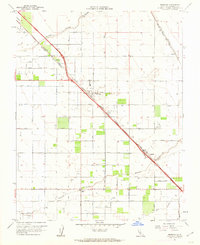
1961 Map of Berenda
USGS Topo · Published 1962About this map
Fairmead and Berenda center this early 1960s survey of Madera County, where the agricultural grid of the San Joaquin Valley is defined by complex irrigation and heavy rail infrastructure. The landscape is dominated by the dual lines of the Southern Pacific and the Atchison Topeka and Santa Fe railroads, which parallel the major thoroughfares of Chowchilla Boulevard and Fairmead Boulevard. A network of water management features, including the Berenda Slough and multiple laterals like Califa Lateral A, supports the orchards and fields that dominate the terrain.
Find a feature on this map
21 named features on this map. Tap any name to fly to it.
Don’t see what you’re looking for? This feature index may not catch every label — zoom into the map to look around manually.
Map Details
Editions of this 1961 Berenda Map
4 editions found
Other maps of this area

1916 · Berenda
USGS Topo · 1:31,680

1918 · Chowchilla
USGS Topo · 1:31,680

1918 · Berenda
USGS Topo · 1:31,680

1918 · La Grand
USGS Topo · 1:31,680

1919 · Plainsberg
USGS Topo · 1:31,680

1919 · Raynor Creek
USGS Topo · 1:31,680

1920 · Kismet
USGS Topo · 1:31,680

1920 · Bonita Ranch
USGS Topo · 1:31,680

1921 · Bonita Ranch
USGS Topo · 1:31,680

1922 · Kentucky Well
USGS Topo · 1:31,680