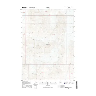
2016 Map of Bering Glacier D-4 SE
USGS Topo · Published 2016About this map
The Kiagna River flows through the northwestern corner of this territory, marking a primary drainage point in a landscape defined by sharp elevation shifts. Much of the central and southern portions of this terrain are managed within the Wrangell-Saint Elias National Park, highlighting the preservation of this interior Alaskan wilderness. The map details the intricate contour lines of high ridges and deep valleys, illustrating the natural barriers and drainages that dictate movement through this remote region. Surveyed for the Public Land Survey System, the map also denotes the boundaries of townships such as t12s r18e and t13s r18e, providing a precise grid for an area otherwise dominated by physical geography rather than human settlement.
Find a feature on this map
8 named features on this map. Tap any name to fly to it.
Don’t see what you’re looking for? This feature index may not catch every label — zoom into the map to look around manually.
Map Details
Editions of this 2016 Bering Glacier D-4 SE Map
This is the sole edition of this map. No revisions or reprints were ever made.
Other maps of this area

1950 · Bering Glacier
USGS Topo · 1:250,000

1951 · Bering Glacier
USGS Topo · 1:250,000

1959 · Bering Glacier
USGS Topo · 1:250,000

1984 · Bering Glacier D-4
USGS Topo · 1:63,360
1984 · Bering Glacier D-3
USGS Topo · 1:63,360
1985 · Bering Glacier C-4
USGS Topo · 1:63,360
1985 · Bering Glacier C-3
USGS Topo · 1:63,360
2016 · Bering Glacier C-4 NE
USGS Topo · 1:25,000
2016 · Bering Glacier C-4 NW
USGS Topo · 1:25,000
2016 · Bering Glacier D-4 SW
USGS Topo · 1:25,000