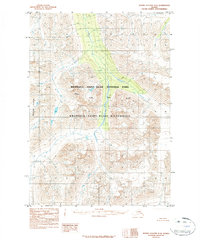
1984 Map of Bering Glacier D-4
USGS Topo · Published 1984About this map
Wrangell-Saint Elias National Park dominates this Alaskan topographic landscape as it was documented in the early 1970s. The map illustrates a high-altitude wilderness shaped by massive ice movements, featuring the extensive Bremner Glacier and the distinct Tana Lobe at its western margin. These frozen features dictate the flow of the West Fork Tana River, which navigates a complex system of valleys between nameless peaks and ridgelines. Because the area falls within the Wrangell-Saint Elias Wilderness, the map shows a landscape entirely devoid of roads or settlements, highlighting the region's preservation as a primitive natural corridor. Geologists and glaciologists can study the specific contours of the ice and the drainage patterns that defined this interior Alaskan terrain prior to the mid-1980s.
Find a feature on this map
5 named features on this map. Tap any name to fly to it.
Don’t see what you’re looking for? This feature index may not catch every label — zoom into the map to look around manually.
Map Details
Editions of this 1984 Bering Glacier D-4 Map
2 editions found
Other maps of this area

1950 · Bering Glacier
USGS Topo · 1:250,000

1951 · McCarthy
USGS Topo · 1:250,000

1951 · Bering Glacier
USGS Topo · 1:250,000

1959 · McCarthy A-4
USGS Topo · 1:63,360

1959 · McCarthy A-5
USGS Topo · 1:63,360

1959 · McCarthy A-3
USGS Topo · 1:63,360

1959 · Bering Glacier
USGS Topo · 1:250,000

1960 · McCarthy
USGS Topo · 1:250,000

1984 · Bering Glacier D-4
USGS Topo · 1:63,360

1984 · Bering Glacier D-5
USGS Topo · 1:63,360