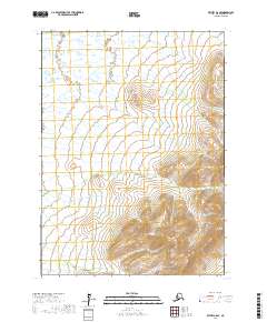
2017 Map of Bethel A-6 SE
USGS Topo · Published 2017About this map
Great Ridge anchors the southeastern corner of this region, providing the primary topographic relief in a landscape otherwise defined by intricate wetland systems. Surveyed for the Bethel area in 2017, the map reveals the complex hydrography of the Alaskan wilderness, where elevation contours at 40-foot intervals delineate the rising slopes of the ridge against the surrounding low-lying basins. The cartography emphasizes the Public Land Survey System grid, specifically marking the boundaries of t1s r69w, t1s r68w, t2s r69w, and t2s r68w. This layout illustrates how large-scale township and range divisions were applied to remote Alaskan territories, serving as a foundational reference for land management and geographic orientation in an area largely devoid of man-made infrastructure or established road networks.
Find a feature on this map
5 named features on this map. Tap any name to fly to it.
Don’t see what you’re looking for? This feature index may not catch every label — zoom into the map to look around manually.
Map Details
Editions of this 2017 Bethel A-6 SE Map
This is the sole edition of this map. No revisions or reprints were ever made.
Other maps of this area

1950 · Bethel
USGS Topo · 1:250,000

1951 · Goodnews
USGS Topo · 1:250,000

1954 · Bethel A-5
USGS Topo · 1:63,360

1954 · Goodnews D-6
USGS Topo · 1:63,360

1954 · Goodnews D-5
USGS Topo · 1:63,360

1954 · Bethel A-6
USGS Topo · 1:63,360
1964 · Bethel A-6
USGS Topo · 1:63,360

1979 · Goodnews Bay
USGS Topo · 1:250,000

1980 · Bethel
USGS Topo · 1:250,000
2017 · Bethel A-6 NW
USGS Topo · 1:25,000