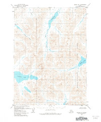
1979 Map of Bethel B-1
USGS Topo · Published 1979About this map
Glacial lake systems and high-altitude drainage basins define this interior Alaskan landscape as it appeared in the late 1970s. The eastern portion of the map is dominated by the northern reaches of Wood-Tikchik State Park, where the high-altitude Upnuk Lake and Chikuminuk Lake sit within deep mountain valleys. These waters feed complex river systems that flow toward the Kuskokwim and Nushagak watersheds, illustrating the hydrologic divide of the region.
Find a feature on this map
9 named features on this map. Tap any name to fly to it.
Don’t see what you’re looking for? This feature index may not catch every label — zoom into the map to look around manually.
Map Details
Editions of this 1979 Bethel B-1 Map
2 editions found
Other maps of this area

1950 · Bethel
USGS Topo · 1:250,000

1950 · Taylor Mountains
USGS Topo · 1:250,000

1951 · Taylor Mountains
USGS Topo · 1:250,000

1954 · Taylor Mountains
USGS Topo · 1:250,000

1954 · Taylor Mountains B-8
USGS Topo · 1:63,360

1954 · Taylor Mountains A-8
USGS Topo · 1:63,360

1954 · Taylor Mountains C-8
USGS Topo · 1:63,360

1979 · Bethel B-1
USGS Topo · 1:63,360

1979 · Bethel A-1
USGS Topo · 1:63,360

1979 · Bethel A-2
USGS Topo · 1:63,360