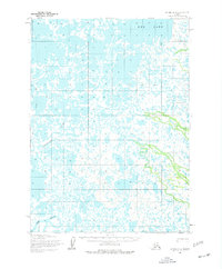
1954 Map of Bethel B-8
USGS Topo · Published 1977About this map
Eenayarak River and the Eek River meander through this low-lying Alaskan landscape, creating a complex network of waterways south of Eek Lake. The terrain is characterized by a dense pattern of lakes and marshes, emphasizing the seasonal nature of travel in this region. A Winter Trail provides a overland route through the western portion of the quadrangle, serving as a vital transportation link when the ground and waterways are frozen. A solitary Cabin is marked along the upper reaches of the Eenayarak River, indicating the sparse, resource-driven settlement patterns of the mid-twentieth century. The presence of these specific river systems and the isolated cabin reflects the subsistence and trapping economy of the area during the early 1950s.
Find a feature on this map
5 named features on this map. Tap any name to fly to it.
Don’t see what you’re looking for? This feature index may not catch every label — zoom into the map to look around manually.
Map Details
Editions of this 1954 Bethel B-8 Map
3 editions found
Other maps of this area

1950 · Bethel
USGS Topo · 1:250,000

1951 · Baird Inlet
USGS Topo · 1:250,000

1954 · Bethel B-7
USGS Topo · 1:63,360

1954 · Bethel B-8
USGS Topo · 1:63,360

1954 · Bethel C-8
USGS Topo · 1:63,360
1954 · Bethel C-7
USGS Topo · 1:63,360
1954 · Bethel A-8
USGS Topo · 1:63,360

1954 · Bethel A-7
USGS Topo · 1:63,360

1954 · Baird Inlet
USGS Topo · 1:250,000

1954 · Baird Inlet B-1
USGS Topo · 1:63,360