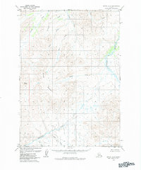
1979 Map of Bethel C-2
USGS Topo · Published 1984About this map
Salmon River and the Kipchuk River flow through this remote portion of Southwest Alaska, defining a landscape dominated by a network of drainage basins. This 1970s topographic study captures the area's hydrology in detail, showing how Porcupine Creek and Cripple Creek carve through the high ground. The terrain is marked by significant elevations including Mount Romig and a feature simply labeled Dome. The absence of roads or permanent settlements in this quadrangle reflects the wilderness character of the region during this era. Numerous smaller waterways such as Bulldog Creek, Quicksilver Creek, and Anvil Creek trace the valleys between unnamed ridges, providing a clear picture of the natural watershed before modern environmental shifts.
Find a feature on this map
12 named features on this map. Tap any name to fly to it.
Don’t see what you’re looking for? This feature index may not catch every label — zoom into the map to look around manually.
Map Details
Editions of this 1979 Bethel C-2 Map
2 editions found
Other maps of this area

1950 · Bethel
USGS Topo · 1:250,000

1954 · Bethel C-3
USGS Topo · 1:63,360

1954 · Bethel D-3
USGS Topo · 1:63,360

1954 · Bethel B-3
USGS Topo · 1:63,360

1979 · Bethel D-2
USGS Topo · 1:63,360

1979 · Bethel B-1
USGS Topo · 1:63,360
1979 · Bethel D-1
USGS Topo · 1:63,360

1979 · Bethel C-2
USGS Topo · 1:63,360

1979 · Bethel B-2
USGS Topo · 1:63,360
1979 · Bethel C-1
USGS Topo · 1:63,360