
1979 Map of Bethel B-2
USGS Topo · Published 1979About this map
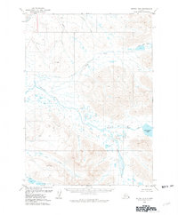
Kisaralik Lake serves as a prominent landmark in this region of southwestern Alaska, where complex glacial and fluvial patterns define the landscape. The hydrography is dominated by the Kisaralik River and its major tributary, the North Fork Kisaralik River, which weave through a network of small ponds and wetland areas. The terrain rises into several distinctive peaks, including those labeled as Silver, Gravel, and Crooked, indicating the mineral and substrate character of the highlands. Smaller watercourses like Quicksilver Cr and Gold Creek drain these elevations, suggesting a history of prospecting or mineral interest in the remote backcountry. The map also captures the North Fork Lakes at the headwaters, providing a detailed look at the drainage systems of the Kisaralik basin before any modern development or infrastructure changed the wild character of the territory.
Find a feature on this map
13 named features on this map. Tap any name to fly to it.
Don’t see what you’re looking for? This feature index may not catch every label — zoom into the map to look around manually.
Map Details
Editions of this 1979 Bethel B-2 Map
2 editions found
Historical Maps of Unorganized Borough Through Time
1082 maps found

1947 Hagemeister Island C-7
Bethel Borough, AK

1947 Russian Mission
Bethel Borough, AK

1948 Hagemeister Island C-5
Bethel Borough, AK

1948 Hagemeister Island C-6
Bethel Borough, AK

1950 Hagemeister Island D-5
Bethel Borough, AK

1950 Hagemeister Island D-6
Bethel Borough, AK

1950 Russian Mission
Bethel Borough, AK

1951 Baird Inlet
Bethel Borough, AK

1951 Cape Mendenhall
Bethel Borough, AK

1951 Kuskokwim Bay
Bethel Borough, AK

1951 Lime Hills
Bethel Borough, AK

1951 Nunivak Island
Bethel Borough, AK

1951 St Matthew
Bethel Borough, AK

1952 Cape Mendenhall
Bethel Borough, AK

1952 Cape Mendenhall D-2
Bethel Borough, AK

1952 Cape Mendenhall D-3
Bethel Borough, AK

1952 Cape Mendenhall D-4
Bethel Borough, AK

1952 Cape Mendenhall D-5
Bethel Borough, AK

1952 Cape Mendenhall D-6
Bethel Borough, AK

1952 Hagemeister Island C-5
Bethel Borough, AK

1952 Hagemeister Island C-6
Bethel Borough, AK

1952 Hagemeister Island C-7
Bethel Borough, AK

1952 Nunivak Island A-2
Bethel Borough, AK

1952 Nunivak Island A-3
Bethel Borough, AK

1952 Nunivak Island A-4
Bethel Borough, AK

1952 Nunivak Island A-5
Bethel Borough, AK

1952 Nunivak Island A-6
Bethel Borough, AK

1952 Nunivak Island A-7
Bethel Borough, AK

1952 Nunivak Island B-2
Bethel Borough, AK

1952 Nunivak Island B-3
Bethel Borough, AK

1952 Nunivak Island B-4
Bethel Borough, AK

1952 Nunivak Island B-5
Bethel Borough, AK

1952 Russian Mission B-1
Bethel Borough, AK

1952 Russian Mission B-2
Bethel Borough, AK

1952 Russian Mission B-3
Bethel Borough, AK

1952 Russian Mission B-6
Bethel Borough, AK

1952 Russian Mission B-7
Bethel Borough, AK

1952 Russian Mission B-8
Bethel Borough, AK

1952 Russian Mission C-1
Bethel Borough, AK

1952 Russian Mission C-2
Bethel Borough, AK

1952 Russian Mission C-3
Bethel Borough, AK

1952 Russian Mission C-5
Bethel Borough, AK

1952 Russian Mission C-6
Bethel Borough, AK

1952 Russian Mission D-1
Bethel Borough, AK

1952 Russian Mission D-2
Bethel Borough, AK

1952 Russian Mission D-3
Bethel Borough, AK

1952 Russian Mission D-4
Bethel Borough, AK

1953 Baird Inlet B-5
Bethel Borough, AK

1953 Baird Inlet C-5
Bethel Borough, AK

1953 Baird Inlet C-6
Bethel Borough, AK

1953 Baird Inlet D-5
Bethel Borough, AK

1953 Kuskokwim Bay D-2
Bethel Borough, AK

1953 Marshall A-5
Bethel Borough, AK

1954 Baird Inlet A-1
Bethel Borough, AK

1954 Baird Inlet A-2
Bethel Borough, AK

1954 Baird Inlet A-3
Bethel Borough, AK

1954 Baird Inlet A-4
Bethel Borough, AK

1954 Baird Inlet A-5
Bethel Borough, AK

1954 Baird Inlet A-6
Bethel Borough, AK

1954 Baird Inlet A-7
Bethel Borough, AK

1954 Baird Inlet B-1
Bethel Borough, AK

1954 Baird Inlet B-2
Bethel Borough, AK

1954 Baird Inlet B-3
Bethel Borough, AK

1954 Baird Inlet B-4
Bethel Borough, AK

1954 Baird Inlet B-6
Bethel Borough, AK

1954 Baird Inlet B-7
Bethel Borough, AK

1954 Baird Inlet B-8
Bethel Borough, AK

1954 Baird Inlet
Bethel Borough, AK

1954 Baird Inlet C-1
Bethel Borough, AK

1954 Baird Inlet C-2
Bethel Borough, AK

1954 Baird Inlet C-3
Bethel Borough, AK

1954 Baird Inlet C-4
Bethel Borough, AK

1954 Baird Inlet C-7
Bethel Borough, AK

1954 Baird Inlet C-8
Bethel Borough, AK

1954 Baird Inlet D-1
Bethel Borough, AK

1954 Baird Inlet D-2
Bethel Borough, AK

1954 Baird Inlet D-3
Bethel Borough, AK

1954 Baird Inlet D-4
Bethel Borough, AK

1954 Baird Inlet D-6
Bethel Borough, AK

1954 Baird Inlet D-7
Bethel Borough, AK

1954 Baird Inlet D-8
Bethel Borough, AK

1954 Bethel A-4
Bethel Borough, AK

1954 Bethel A-5
Bethel Borough, AK

1954 Bethel A-6
Bethel Borough, AK

1954 Bethel A-7
Bethel Borough, AK

1954 Bethel A-8
Bethel Borough, AK

1954 Bethel B-3
Bethel Borough, AK

1954 Bethel B-4
Bethel Borough, AK

1954 Bethel B-5
Bethel Borough, AK

1954 Bethel B-6
Bethel Borough, AK

1954 Bethel B-7
Bethel Borough, AK

1954 Bethel B-8
Bethel Borough, AK

1954 Bethel C-3
Bethel Borough, AK

1954 Bethel C-4
Bethel Borough, AK

1954 Bethel C-5
Bethel Borough, AK

1954 Bethel C-6
Bethel Borough, AK

1954 Bethel C-7
Bethel Borough, AK

1954 Bethel C-8
Bethel Borough, AK

1954 Bethel D-3
Bethel Borough, AK

1954 Bethel D-4
Bethel Borough, AK

1954 Bethel D-5
Bethel Borough, AK

1954 Bethel D-6
Bethel Borough, AK

1954 Bethel D-7
Bethel Borough, AK

1954 Bethel D-8
Bethel Borough, AK

1954 Goodnews A-6
Bethel Borough, AK

1954 Goodnews B-6
Bethel Borough, AK

1954 Goodnews B-8
Bethel Borough, AK

1954 Goodnews Bay A-7
Bethel Borough, AK

1954 Goodnews Bay A-8
Bethel Borough, AK

1954 Goodnews Bay B-7
Bethel Borough, AK

1954 Goodnews Bay D-8
Bethel Borough, AK

1954 Goodnews C-6
Bethel Borough, AK

1954 Goodnews C-7
Bethel Borough, AK

1954 Goodnews C-8
Bethel Borough, AK

1954 Goodnews D-4
Bethel Borough, AK

1954 Goodnews D-5
Bethel Borough, AK

1954 Goodnews D-6
Bethel Borough, AK

1954 Goodnews D-7
Bethel Borough, AK

1954 Hagemeister Island D-4
Bethel Borough, AK

1954 Hagemeister Island D-5
Bethel Borough, AK

1954 Kuskokwim Bay
Bethel Borough, AK

1954 Kuskokwim Bay D-1
Bethel Borough, AK

1954 Kuskokwim Bay D-3
Bethel Borough, AK

1954 Kuskokwim Bay D-4
Bethel Borough, AK

1954 Kuskokwim Bay D-5
Bethel Borough, AK

1954 Kuskokwim Bay D-6
Bethel Borough, AK

1954 Kuskokwim Bay D-7
Bethel Borough, AK

1954 Lime Hills A-3
Bethel Borough, AK

1954 Lime Hills A-4
Bethel Borough, AK

1954 Lime Hills A-5
Bethel Borough, AK

1954 Lime Hills A-6
Bethel Borough, AK

1954 Lime Hills A-7
Bethel Borough, AK

1954 Lime Hills A-8
Bethel Borough, AK

1954 Lime Hills B-3
Bethel Borough, AK

1954 Lime Hills B-4
Bethel Borough, AK

1954 Lime Hills B-5
Bethel Borough, AK

1954 Lime Hills B-6
Bethel Borough, AK

1954 Lime Hills B-7
Bethel Borough, AK

1954 Lime Hills B-8
Bethel Borough, AK

1954 Lime Hills C-5
Bethel Borough, AK

1954 Lime Hills C-6
Bethel Borough, AK

1954 Lime Hills C-7
Bethel Borough, AK

1954 Lime Hills D-5
Bethel Borough, AK

1954 Lime Hills D-6
Bethel Borough, AK

1954 Lime Hills D-7
Bethel Borough, AK

1954 Lime Hills D-8
Bethel Borough, AK

1954 Marshall A-1
Bethel Borough, AK

1954 Marshall A-2
Bethel Borough, AK

1954 Marshall A-3
Bethel Borough, AK

1954 Marshall A-4
Bethel Borough, AK

1954 Marshall A-6
Bethel Borough, AK

1954 Marshall B-1
Bethel Borough, AK

1954 Marshall B-2
Bethel Borough, AK

1954 Marshall B-3
Bethel Borough, AK

1954 Marshall B-4
Bethel Borough, AK

1954 Nunivak Island B-1
Bethel Borough, AK

1954 Nunivak Island
Bethel Borough, AK

1954 Nunivak Island C-1
Bethel Borough, AK

1954 Nunivak Island D-1
Bethel Borough, AK

1954 Russian Mission A-3
Bethel Borough, AK

1954 Russian Mission A-4
Bethel Borough, AK

1954 Russian Mission A-5
Bethel Borough, AK

1954 Russian Mission A-6
Bethel Borough, AK

1954 Russian Mission A-7
Bethel Borough, AK

1954 Russian Mission A-8
Bethel Borough, AK

1954 Russian Mission B-4
Bethel Borough, AK

1954 Russian Mission B-5
Bethel Borough, AK

1954 Russian Mission C-4
Bethel Borough, AK

1954 Sleetmute A-1
Bethel Borough, AK

1954 Sleetmute A-2
Bethel Borough, AK

1954 Sleetmute A-3
Bethel Borough, AK

1954 Sleetmute A-4
Bethel Borough, AK

1954 Sleetmute A-5
Bethel Borough, AK

1954 Sleetmute A-6
Bethel Borough, AK

1954 Sleetmute A-7
Bethel Borough, AK

1954 Sleetmute A-8
Bethel Borough, AK

1954 Sleetmute B-1
Bethel Borough, AK

1954 Sleetmute B-2
Bethel Borough, AK

1954 Sleetmute B-3
Bethel Borough, AK

1954 Sleetmute B-4
Bethel Borough, AK

1954 Sleetmute B-5
Bethel Borough, AK

1954 Sleetmute B-6
Bethel Borough, AK

1954 Sleetmute B-7
Bethel Borough, AK

1954 Sleetmute B-8
Bethel Borough, AK

1954 Sleetmute C-1
Bethel Borough, AK

1954 Sleetmute C-2
Bethel Borough, AK

1954 Sleetmute C-3
Bethel Borough, AK

1954 Sleetmute C-4
Bethel Borough, AK

1954 Sleetmute C-5
Bethel Borough, AK

1954 Sleetmute C-6
Bethel Borough, AK

1954 Sleetmute C-8
Bethel Borough, AK

1954 Sleetmute D-1
Bethel Borough, AK

1954 Sleetmute D-2
Bethel Borough, AK

1954 Sleetmute D-3
Bethel Borough, AK

1954 Sleetmute D-4
Bethel Borough, AK

1954 Sleetmute D-5
Bethel Borough, AK

1954 Sleetmute D-6
Bethel Borough, AK

1954 Sleetmute D-7
Bethel Borough, AK

1954 Sleetmute D-8
Bethel Borough, AK

1957 Sleetmute C-7
Bethel Borough, AK

1958 Lime Hills A-2
Bethel Borough, AK

1958 Lime Hills B-2
Bethel Borough, AK

1958 Lime Hills
Bethel Borough, AK

1958 Lime Hills C-1
Bethel Borough, AK

1958 Lime Hills C-2
Bethel Borough, AK

1958 Lime Hills C-3
Bethel Borough, AK

1958 Lime Hills C-4
Bethel Borough, AK

1958 Lime Hills C-8
Bethel Borough, AK

1958 Lime Hills D-1
Bethel Borough, AK

1958 Lime Hills D-2
Bethel Borough, AK

1958 Lime Hills D-3
Bethel Borough, AK

1958 Lime Hills D-4
Bethel Borough, AK

1958 McGrath A-1
Bethel Borough, AK

1958 Nunivak Island
Bethel Borough, AK

1964 Bethel A-6
Bethel Borough, AK

1964 Nunivak Island
Bethel Borough, AK

1969 St. Matthew
Bethel Borough, AK

1979 Bethel A-3
Bethel Borough, AK
1979 Bethel B-2
Bethel Borough, AK

1979 Bethel C-2
Bethel Borough, AK

1979 Bethel D-1
Bethel Borough, AK

1979 Bethel D-2
Bethel Borough, AK

1979 Goodnews Bay B-5
Bethel Borough, AK

1979 Goodnews Bay C-5
Bethel Borough, AK

1979 Russian Mission A-1
Bethel Borough, AK

1979 Russian Mission A-2
Bethel Borough, AK

1980 Russian Mission
Bethel Borough, AK

2017 Baird Inlet A-1 NE
Bethel Borough, AK

2017 Baird Inlet A-1 NW
Bethel Borough, AK

2017 Baird Inlet A-1 SE
Bethel Borough, AK

2017 Baird Inlet A-1 SW
Bethel Borough, AK

2017 Baird Inlet A-2 NE
Bethel Borough, AK

2017 Baird Inlet A-2 NW
Bethel Borough, AK

2017 Baird Inlet A-2 SE
Bethel Borough, AK

2017 Baird Inlet A-2 SW
Bethel Borough, AK

2017 Baird Inlet A-3 NE
Bethel Borough, AK

2017 Baird Inlet A-3 SE
Bethel Borough, AK

2017 Baird Inlet B-1 NE
Bethel Borough, AK

2017 Baird Inlet B-1 NW
Bethel Borough, AK

2017 Baird Inlet B-1 SE
Bethel Borough, AK

2017 Baird Inlet B-1 SW
Bethel Borough, AK

2017 Baird Inlet B-2 NE
Bethel Borough, AK

2017 Baird Inlet B-2 NW
Bethel Borough, AK

2017 Baird Inlet B-2 SE
Bethel Borough, AK

2017 Baird Inlet B-2 SW
Bethel Borough, AK

2017 Baird Inlet B-3 NE
Bethel Borough, AK

2017 Baird Inlet B-3 SE
Bethel Borough, AK

2017 Baird Inlet C-1 NE
Bethel Borough, AK

2017 Baird Inlet C-1 NW
Bethel Borough, AK

2017 Baird Inlet C-1 SE
Bethel Borough, AK

2017 Baird Inlet C-1 SW
Bethel Borough, AK

2017 Baird Inlet C-2 NE
Bethel Borough, AK

2017 Baird Inlet C-2 NW
Bethel Borough, AK

2017 Baird Inlet C-2 SE
Bethel Borough, AK

2017 Baird Inlet C-2 SW
Bethel Borough, AK

2017 Baird Inlet C-3 NE
Bethel Borough, AK

2017 Baird Inlet C-3 SE
Bethel Borough, AK

2017 Baird Inlet D-1 NE
Bethel Borough, AK

2017 Baird Inlet D-1 NW
Bethel Borough, AK

2017 Baird Inlet D-1 SE
Bethel Borough, AK

2017 Baird Inlet D-1 SW
Bethel Borough, AK

2017 Baird Inlet D-2 NE
Bethel Borough, AK

2017 Baird Inlet D-2 NW
Bethel Borough, AK

2017 Baird Inlet D-2 SE
Bethel Borough, AK

2017 Baird Inlet D-2 SW
Bethel Borough, AK

2017 Baird Inlet D-3 NE
Bethel Borough, AK

2017 Baird Inlet D-3 SE
Bethel Borough, AK

2017 Bethel A-4 NE
Bethel Borough, AK

2017 Bethel A-4 NW
Bethel Borough, AK

2017 Bethel A-4 SE
Bethel Borough, AK

2017 Bethel A-4 SW
Bethel Borough, AK

2017 Bethel A-5 NE
Bethel Borough, AK

2017 Bethel A-5 NW
Bethel Borough, AK

2017 Bethel A-5 SE
Bethel Borough, AK

2017 Bethel A-5 SW
Bethel Borough, AK

2017 Bethel A-6 NE
Bethel Borough, AK

2017 Bethel A-6 NW
Bethel Borough, AK

2017 Bethel A-6 SE
Bethel Borough, AK

2017 Bethel A-6 SW
Bethel Borough, AK

2017 Bethel A-7 NE
Bethel Borough, AK

2017 Bethel A-7 NW
Bethel Borough, AK

2017 Bethel A-7 SE
Bethel Borough, AK

2017 Bethel A-7 SW
Bethel Borough, AK

2017 Bethel A-8 NE
Bethel Borough, AK

2017 Bethel A-8 NW
Bethel Borough, AK

2017 Bethel A-8 SE
Bethel Borough, AK

2017 Bethel A-8 SW
Bethel Borough, AK

2017 Bethel B-4 NE
Bethel Borough, AK

2017 Bethel B-4 NW
Bethel Borough, AK

2017 Bethel B-4 SE
Bethel Borough, AK

2017 Bethel B-4 SW
Bethel Borough, AK

2017 Bethel B-5 NE
Bethel Borough, AK

2017 Bethel B-5 NW
Bethel Borough, AK

2017 Bethel B-5 SE
Bethel Borough, AK

2017 Bethel B-5 SW
Bethel Borough, AK

2017 Bethel B-6 NE
Bethel Borough, AK

2017 Bethel B-6 NW
Bethel Borough, AK

2017 Bethel B-6 SE
Bethel Borough, AK

2017 Bethel B-6 SW
Bethel Borough, AK

2017 Bethel B-7 NE
Bethel Borough, AK

2017 Bethel B-7 NW
Bethel Borough, AK

2017 Bethel B-7 SE
Bethel Borough, AK

2017 Bethel B-7 SW
Bethel Borough, AK

2017 Bethel B-8 NE
Bethel Borough, AK

2017 Bethel B-8 NW
Bethel Borough, AK

2017 Bethel B-8 SE
Bethel Borough, AK

2017 Bethel B-8 SW
Bethel Borough, AK

2017 Bethel C-4 NE
Bethel Borough, AK

2017 Bethel C-4 NW
Bethel Borough, AK

2017 Bethel C-4 SE
Bethel Borough, AK

2017 Bethel C-4 SW
Bethel Borough, AK

2017 Bethel C-5 NE
Bethel Borough, AK

2017 Bethel C-5 NW
Bethel Borough, AK

2017 Bethel C-5 SE
Bethel Borough, AK

2017 Bethel C-5 SW
Bethel Borough, AK

2017 Bethel C-6 NE
Bethel Borough, AK

2017 Bethel C-6 NW
Bethel Borough, AK

2017 Bethel C-6 SE
Bethel Borough, AK

2017 Bethel C-6 SW
Bethel Borough, AK

2017 Bethel C-7 NE
Bethel Borough, AK

2017 Bethel C-7 NW
Bethel Borough, AK

2017 Bethel C-7 SE
Bethel Borough, AK

2017 Bethel C-7 SW
Bethel Borough, AK

2017 Bethel C-8 NE
Bethel Borough, AK

2017 Bethel C-8 NW
Bethel Borough, AK

2017 Bethel C-8 SE
Bethel Borough, AK

2017 Bethel C-8 SW
Bethel Borough, AK

2017 Bethel D-4 NE
Bethel Borough, AK

2017 Bethel D-4 NW
Bethel Borough, AK

2017 Bethel D-4 SE
Bethel Borough, AK

2017 Bethel D-4 SW
Bethel Borough, AK

2017 Bethel D-5 NE
Bethel Borough, AK

2017 Bethel D-5 NW
Bethel Borough, AK

2017 Bethel D-5 SE
Bethel Borough, AK

2017 Bethel D-5 SW
Bethel Borough, AK

2017 Bethel D-6 NE
Bethel Borough, AK

2017 Bethel D-6 NW
Bethel Borough, AK

2017 Bethel D-6 SE
Bethel Borough, AK

2017 Bethel D-6 SW
Bethel Borough, AK

2017 Bethel D-7 NE
Bethel Borough, AK

2017 Bethel D-7 NW
Bethel Borough, AK

2017 Bethel D-7 SE
Bethel Borough, AK

2017 Bethel D-7 SW
Bethel Borough, AK

2017 Bethel D-8 NE
Bethel Borough, AK

2017 Bethel D-8 NW
Bethel Borough, AK

2017 Bethel D-8 SE
Bethel Borough, AK

2017 Bethel D-8 SW
Bethel Borough, AK

2017 Goodnews Bay A-6 NW
Bethel Borough, AK

2017 Goodnews Bay A-6 SW
Bethel Borough, AK

2017 Goodnews Bay A-7 NE
Bethel Borough, AK

2017 Goodnews Bay A-7 NW
Bethel Borough, AK

2017 Goodnews Bay A-7 SE
Bethel Borough, AK

2017 Goodnews Bay A-7 SW
Bethel Borough, AK

2017 Goodnews Bay A-8 NE
Bethel Borough, AK

2017 Goodnews Bay A-8 NW
Bethel Borough, AK

2017 Goodnews Bay A-8 SE
Bethel Borough, AK

2017 Goodnews Bay A-8 SW
Bethel Borough, AK

2017 Goodnews Bay B-6 NW
Bethel Borough, AK

2017 Goodnews Bay B-6 SW
Bethel Borough, AK

2017 Goodnews Bay B-7 NE
Bethel Borough, AK

2017 Goodnews Bay B-7 NW
Bethel Borough, AK

2017 Goodnews Bay B-7 SE
Bethel Borough, AK

2017 Goodnews Bay B-7 SW
Bethel Borough, AK

2017 Goodnews Bay B-8 NE
Bethel Borough, AK

2017 Goodnews Bay B-8 NW
Bethel Borough, AK

2017 Goodnews Bay B-8 SE
Bethel Borough, AK

2017 Goodnews Bay B-8 SW
Bethel Borough, AK

2017 Goodnews Bay C-6 NW
Bethel Borough, AK

2017 Goodnews Bay C-6 SW
Bethel Borough, AK

2017 Goodnews Bay C-7 NE
Bethel Borough, AK

2017 Goodnews Bay C-7 NW
Bethel Borough, AK

2017 Goodnews Bay C-7 SE
Bethel Borough, AK

2017 Goodnews Bay C-7 SW
Bethel Borough, AK

2017 Goodnews Bay C-8 NE
Bethel Borough, AK

2017 Goodnews Bay C-8 NW
Bethel Borough, AK

2017 Goodnews Bay C-8 SE
Bethel Borough, AK

2017 Goodnews Bay C-8 SW
Bethel Borough, AK

2017 Goodnews Bay D-6 NW
Bethel Borough, AK

2017 Goodnews Bay D-6 SW
Bethel Borough, AK

2017 Goodnews Bay D-7 NE
Bethel Borough, AK

2017 Goodnews Bay D-7 NW
Bethel Borough, AK

2017 Goodnews Bay D-7 SE
Bethel Borough, AK

2017 Goodnews Bay D-7 SW
Bethel Borough, AK

2017 Goodnews Bay D-8 NE
Bethel Borough, AK

2017 Goodnews Bay D-8 NW
Bethel Borough, AK

2017 Goodnews Bay D-8 SE
Bethel Borough, AK

2017 Goodnews Bay D-8 SW
Bethel Borough, AK

2017 Lime Hills B-1 NE
Bethel Borough, AK

2017 Lime Hills C-1 SE
Bethel Borough, AK

2017 Lime Hills D-1 NE
Bethel Borough, AK

2017 Lime Hills D-1 SE
Bethel Borough, AK

2017 McGrath A-1 SE
Bethel Borough, AK

2017 Russian Mission A-4 NE
Bethel Borough, AK

2017 Russian Mission A-4 NW
Bethel Borough, AK

2017 Russian Mission A-4 SE
Bethel Borough, AK

2017 Russian Mission A-4 SW
Bethel Borough, AK

2017 Russian Mission A-5 NE
Bethel Borough, AK

2017 Russian Mission A-5 NW
Bethel Borough, AK

2017 Russian Mission A-5 SE
Bethel Borough, AK

2017 Russian Mission A-5 SW
Bethel Borough, AK

2017 Russian Mission A-6 NE
Bethel Borough, AK

2017 Russian Mission A-6 NW
Bethel Borough, AK

2017 Russian Mission A-6 SE
Bethel Borough, AK

2017 Russian Mission A-6 SW
Bethel Borough, AK

2017 Russian Mission A-7 NE
Bethel Borough, AK

2017 Russian Mission A-7 NW
Bethel Borough, AK

2017 Russian Mission A-7 SE
Bethel Borough, AK

2017 Russian Mission A-7 SW
Bethel Borough, AK

2017 Russian Mission A-8 NE
Bethel Borough, AK

2017 Russian Mission A-8 NW
Bethel Borough, AK

2017 Russian Mission A-8 SE
Bethel Borough, AK

2017 Russian Mission A-8 SW
Bethel Borough, AK

2017 Russian Mission B-4 NE
Bethel Borough, AK

2017 Russian Mission B-4 NW
Bethel Borough, AK

2017 Russian Mission B-4 SE
Bethel Borough, AK

2017 Russian Mission B-4 SW
Bethel Borough, AK

2017 Russian Mission B-5 NE
Bethel Borough, AK

2017 Russian Mission B-5 NW
Bethel Borough, AK

2017 Russian Mission B-5 SE
Bethel Borough, AK

2017 Russian Mission B-5 SW
Bethel Borough, AK

2017 Russian Mission B-6 NE
Bethel Borough, AK

2017 Russian Mission B-6 NW
Bethel Borough, AK

2017 Russian Mission B-6 SE
Bethel Borough, AK

2017 Russian Mission B-6 SW
Bethel Borough, AK

2017 Russian Mission B-7 NE
Bethel Borough, AK

2017 Russian Mission B-7 NW
Bethel Borough, AK

2017 Russian Mission B-7 SE
Bethel Borough, AK

2017 Russian Mission B-7 SW
Bethel Borough, AK

2017 Russian Mission B-8 NE
Bethel Borough, AK

2017 Russian Mission B-8 NW
Bethel Borough, AK

2017 Russian Mission B-8 SE
Bethel Borough, AK

2017 Russian Mission B-8 SW
Bethel Borough, AK

2017 Russian Mission C-4 NE
Bethel Borough, AK

2017 Russian Mission C-4 NW
Bethel Borough, AK

2017 Russian Mission C-4 SE
Bethel Borough, AK

2017 Russian Mission C-4 SW
Bethel Borough, AK

2017 Russian Mission C-5 NE
Bethel Borough, AK

2017 Russian Mission C-5 NW
Bethel Borough, AK

2017 Russian Mission C-5 SE
Bethel Borough, AK

2017 Russian Mission C-5 SW
Bethel Borough, AK

2017 Russian Mission C-6 SE
Bethel Borough, AK

2017 Russian Mission C-6 SW
Bethel Borough, AK

2017 Russian Mission C-7 SE
Bethel Borough, AK

2017 Russian Mission D-4 NE
Bethel Borough, AK

2017 Russian Mission D-4 NW
Bethel Borough, AK

2017 Russian Mission D-4 SE
Bethel Borough, AK

2017 Russian Mission D-4 SW
Bethel Borough, AK

2018 Hagemeister Island C-4 NW
Bethel Borough, AK

2018 Hagemeister Island C-5 NE
Bethel Borough, AK

2018 Hagemeister Island C-5 NW
Bethel Borough, AK

2018 Hagemeister Island C-5 SW
Bethel Borough, AK

2018 Hagemeister Island C-6 NE
Bethel Borough, AK

2018 Hagemeister Island C-6 NW
Bethel Borough, AK

2018 Hagemeister Island C-6 SE
Bethel Borough, AK

2018 Hagemeister Island C-6 SW
Bethel Borough, AK

2018 Hagemeister Island C-7 NE
Bethel Borough, AK

2018 Hagemeister Island C-7 NW
Bethel Borough, AK

2018 Hagemeister Island C-7 SE
Bethel Borough, AK

2018 Hagemeister Island D-4 NE
Bethel Borough, AK

2018 Hagemeister Island D-4 NW
Bethel Borough, AK

2018 Hagemeister Island D-4 SE
Bethel Borough, AK

2018 Hagemeister Island D-4 SW
Bethel Borough, AK

2018 Hagemeister Island D-5 NE
Bethel Borough, AK

2018 Hagemeister Island D-5 NW
Bethel Borough, AK

2018 Hagemeister Island D-5 SE
Bethel Borough, AK

2018 Hagemeister Island D-5 SW
Bethel Borough, AK

2018 Hagemeister Island D-6 NE
Bethel Borough, AK

2018 Hagemeister Island D-6 NW
Bethel Borough, AK

2018 Hagemeister Island D-6 SE
Bethel Borough, AK

2018 Hagemeister Island D-6 SW
Bethel Borough, AK

2018 Kuskokwim Bay A-1 NE
Bethel Borough, AK

2018 Kuskokwim Bay B-1 SE
Bethel Borough, AK

2018 Kuskokwim Bay D-1 NE
Bethel Borough, AK

2018 Kuskokwim Bay D-1 SE
Bethel Borough, AK

2018 Kuskokwim Bay D-2 NE
Bethel Borough, AK

2018 Kuskokwim Bay D-2 NW
Bethel Borough, AK

2018 Kuskokwim Bay D-3 NE
Bethel Borough, AK

2018 Lake Clark D-2 NE
Bethel Borough, AK

2018 Lake Clark D-2 NW
Bethel Borough, AK

2018 Lake Clark D-3 NE
Bethel Borough, AK

2018 Lake Clark D-4 NE
Bethel Borough, AK

2018 Lake Clark D-4 NW
Bethel Borough, AK

2018 Lake Clark D-5 NE
Bethel Borough, AK

2018 Lake Clark D-5 NW
Bethel Borough, AK

2018 Marshall A-1 NE
Bethel Borough, AK

2018 Marshall A-1 NW
Bethel Borough, AK

2018 Marshall A-1 SE
Bethel Borough, AK

2018 Marshall A-1 SW
Bethel Borough, AK

2018 Marshall A-2 NE
Bethel Borough, AK

2018 Marshall A-2 NW
Bethel Borough, AK

2018 Marshall A-2 SE
Bethel Borough, AK

2018 Marshall A-2 SW
Bethel Borough, AK

2018 Marshall A-3 NE
Bethel Borough, AK

2018 Marshall A-3 SE
Bethel Borough, AK

2018 Marshall B-1 NE
Bethel Borough, AK

2018 Marshall B-1 NW
Bethel Borough, AK

2018 Marshall B-1 SE
Bethel Borough, AK

2018 Marshall B-1 SW
Bethel Borough, AK

2018 Marshall B-2 NE
Bethel Borough, AK

2018 Marshall B-2 NW
Bethel Borough, AK

2018 Marshall B-2 SE
Bethel Borough, AK

2018 Marshall B-2 SW
Bethel Borough, AK

2018 Marshall B-3 NE
Bethel Borough, AK

2018 Marshall B-3 SE
Bethel Borough, AK

2019 Bethel A-3 NE
Bethel Borough, AK

2019 Bethel A-3 NW
Bethel Borough, AK

2019 Bethel A-3 SW
Bethel Borough, AK

2019 Bethel B-2 NE
Bethel Borough, AK

2019 Bethel B-2 NW
Bethel Borough, AK

2019 Bethel B-2 SW
Bethel Borough, AK

2019 Bethel B-3 NE
Bethel Borough, AK

2019 Bethel B-3 NW
Bethel Borough, AK

2019 Bethel B-3 SE
Bethel Borough, AK

2019 Bethel B-3 SW
Bethel Borough, AK

2019 Bethel C-1 NW
Bethel Borough, AK

2019 Bethel C-2 NE
Bethel Borough, AK

2019 Bethel C-2 NW
Bethel Borough, AK

2019 Bethel C-2 SE
Bethel Borough, AK

2019 Bethel C-2 SW
Bethel Borough, AK

2019 Bethel C-3 NE
Bethel Borough, AK

2019 Bethel C-3 NW
Bethel Borough, AK

2019 Bethel C-3 SE
Bethel Borough, AK

2019 Bethel C-3 SW
Bethel Borough, AK

2019 Bethel D-1 NE
Bethel Borough, AK

2019 Bethel D-1 NW
Bethel Borough, AK

2019 Bethel D-1 SE
Bethel Borough, AK

2019 Bethel D-1 SW
Bethel Borough, AK

2019 Bethel D-2 NE
Bethel Borough, AK

2019 Bethel D-2 NW
Bethel Borough, AK

2019 Bethel D-2 SE
Bethel Borough, AK

2019 Bethel D-2 SW
Bethel Borough, AK

2019 Bethel D-3 NE
Bethel Borough, AK

2019 Bethel D-3 NW
Bethel Borough, AK

2019 Bethel D-3 SE
Bethel Borough, AK

2019 Bethel D-3 SW
Bethel Borough, AK

2019 Goodnews Bay D-3 NW
Bethel Borough, AK

2019 Iditarod A-3 SE
Bethel Borough, AK

2019 Iditarod A-3 SW
Bethel Borough, AK

2019 Iditarod A-4 SE
Bethel Borough, AK

2019 Iditarod A-4 SW
Bethel Borough, AK

2019 Iditarod A-5 SE
Bethel Borough, AK

2019 Iditarod A-5 SW
Bethel Borough, AK

2019 Lake Clark D-6 NE
Bethel Borough, AK

2019 Lake Clark D-6 NW
Bethel Borough, AK

2019 Lake Clark D-7 NE
Bethel Borough, AK

2019 Lake Clark D-7 NW
Bethel Borough, AK

2019 Lake Clark D-8 NE
Bethel Borough, AK

2019 Lake Clark D-8 NW
Bethel Borough, AK

2019 Lime Hills A-2 NW
Bethel Borough, AK

2019 Lime Hills A-2 SE
Bethel Borough, AK

2019 Lime Hills A-2 SW
Bethel Borough, AK

2019 Lime Hills A-3 NE
Bethel Borough, AK

2019 Lime Hills A-3 NW
Bethel Borough, AK

2019 Lime Hills A-3 SE
Bethel Borough, AK

2019 Lime Hills A-3 SW
Bethel Borough, AK

2019 Lime Hills A-4 NE
Bethel Borough, AK

2019 Lime Hills A-4 NW
Bethel Borough, AK

2019 Lime Hills A-4 SE
Bethel Borough, AK

2019 Lime Hills A-4 SW
Bethel Borough, AK

2019 Lime Hills A-5 NE
Bethel Borough, AK

2019 Lime Hills A-5 NW
Bethel Borough, AK

2019 Lime Hills A-5 SE
Bethel Borough, AK

2019 Lime Hills A-5 SW
Bethel Borough, AK

2019 Lime Hills A-6 NE
Bethel Borough, AK

2019 LIme Hills A-6 NW
Bethel Borough, AK

2019 Lime Hills A-6 SE
Bethel Borough, AK

2019 Lime Hills A-6 SW
Bethel Borough, AK

2019 Lime Hills A-7 NE
Bethel Borough, AK

2019 Lime Hills A-7 NW
Bethel Borough, AK

2019 Lime Hills A-7 SE
Bethel Borough, AK

2019 Lime Hills A-7 SW
Bethel Borough, AK

2019 Lime Hills A-8 NE
Bethel Borough, AK

2019 Lime Hills A-8 NW
Bethel Borough, AK

2019 Lime Hills A-8 SE
Bethel Borough, AK

2019 Lime Hills A-8 SW
Bethel Borough, AK

2019 Lime Hills B-1 NE
Bethel Borough, AK

2019 Lime Hills B-1 NW
Bethel Borough, AK

2019 Lime Hills B-2 NE
Bethel Borough, AK

2019 Lime Hills B-2 NW
Bethel Borough, AK

2019 Lime Hills B-2 SW
Bethel Borough, AK

2019 Lime Hills B-3 NE
Bethel Borough, AK

2019 Lime Hills B-3 NW
Bethel Borough, AK

2019 Lime Hills B-3 SE
Bethel Borough, AK

2019 Lime Hills B-3 SW
Bethel Borough, AK

2019 Lime Hills B-4 NE
Bethel Borough, AK

2019 Lime Hills B-4 NW
Bethel Borough, AK

2019 Lime Hills B-4 SE
Bethel Borough, AK

2019 Lime Hills B-4 SW
Bethel Borough, AK

2019 Lime Hills B-5 NE
Bethel Borough, AK

2019 Lime Hills B-5 NW
Bethel Borough, AK

2019 Lime Hills B-5 SE
Bethel Borough, AK

2019 Lime Hills B-5 SW
Bethel Borough, AK

2019 Lime Hills B-6 NE
Bethel Borough, AK

2019 Lime Hills B-6 NW
Bethel Borough, AK

2019 Lime Hills B-6 SE
Bethel Borough, AK

2019 Lime Hills B-6 SW
Bethel Borough, AK

2019 Lime Hills B-7 NE
Bethel Borough, AK

2019 Lime Hills B-7 NW
Bethel Borough, AK

2019 Lime Hills B-7 SE
Bethel Borough, AK

2019 Lime Hills B-7 SW
Bethel Borough, AK

2019 Lime Hills B-8 NE
Bethel Borough, AK

2019 Lime Hills B-8 NW
Bethel Borough, AK

2019 Lime Hills B-8 SE
Bethel Borough, AK

2019 Lime Hills B-8 SW
Bethel Borough, AK

2019 LIme Hills C-1 NE
Bethel Borough, AK

2019 Lime Hills C-1 NW
Bethel Borough, AK

2019 Lime Hills C-1 SE
Bethel Borough, AK

2019 LIme Hills C-1 SW
Bethel Borough, AK

2019 Lime Hills C-2 NE
Bethel Borough, AK

2019 Lime Hills C-2 NW
Bethel Borough, AK

2019 Lime Hills C-2 SE
Bethel Borough, AK

2019 Lime Hills C-2 SW
Bethel Borough, AK

2019 Lime Hills C-3 NE
Bethel Borough, AK

2019 Lime Hills C-3 NW
Bethel Borough, AK

2019 Lime Hills C-3 SE
Bethel Borough, AK

2019 Lime Hills C-3 SW
Bethel Borough, AK

2019 Lime Hills C-4 NE
Bethel Borough, AK

2019 Lime Hills C-4 NW
Bethel Borough, AK

2019 Lime Hills C-4 SE
Bethel Borough, AK

2019 Lime Hills C-4 SW
Bethel Borough, AK

2019 Lime Hills C-5 NE
Bethel Borough, AK

2019 Lime Hills C-5 NW
Bethel Borough, AK

2019 Lime Hills C-5 SE
Bethel Borough, AK

2019 Lime Hills C-5 SW
Bethel Borough, AK

2019 Lime Hills C-6 NE
Bethel Borough, AK

2019 Lime Hills C-6 NW
Bethel Borough, AK

2019 Lime Hills C-6 SE
Bethel Borough, AK

2019 Lime Hills C-6 SW
Bethel Borough, AK

2019 Lime Hills C-7 NE
Bethel Borough, AK

2019 Lime Hills C-7 NW
Bethel Borough, AK

2019 Lime Hills C-7 SE
Bethel Borough, AK

2019 Lime Hills C-7 SW
Bethel Borough, AK

2019 Lime Hills C-8 NE
Bethel Borough, AK

2019 Lime Hills C-8 NW
Bethel Borough, AK

2019 Lime Hills C-8 SE
Bethel Borough, AK

2019 Lime Hills C-8 SW
Bethel Borough, AK

2019 Lime Hills D-1 NE
Bethel Borough, AK

2019 Lime Hills D-1 NW
Bethel Borough, AK

2019 Lime Hills D-1 SE
Bethel Borough, AK

2019 Lime Hills D-1 SW
Bethel Borough, AK

2019 Lime Hills D-2 NE
Bethel Borough, AK

2019 Lime Hills D-2 NW
Bethel Borough, AK

2019 Lime Hills D-2 SE
Bethel Borough, AK

2019 Lime Hills D-2 SW
Bethel Borough, AK

2019 Lime Hills D-3 NE
Bethel Borough, AK

2019 Lime Hills D-3 NW
Bethel Borough, AK

2019 Lime Hills D-3 SE
Bethel Borough, AK

2019 Lime Hills D-3 SW
Bethel Borough, AK

2019 Lime Hills D-4 NE
Bethel Borough, AK

2019 Lime Hills D-4 NW
Bethel Borough, AK

2019 Lime Hills D-4 SE
Bethel Borough, AK

2019 Lime Hills D-4 SW
Bethel Borough, AK

2019 Lime Hills D-5 NE
Bethel Borough, AK

2019 Lime Hills D-5 NW
Bethel Borough, AK

2019 Lime Hills D-5 SE
Bethel Borough, AK

2019 Lime Hills D-5 SW
Bethel Borough, AK

2019 Lime Hills D-6 NE
Bethel Borough, AK

2019 Lime Hills D-6 NW
Bethel Borough, AK

2019 Lime Hills D-6 SE
Bethel Borough, AK

2019 LIme Hills D-6 SW
Bethel Borough, AK

2019 LIme Hills D-7 NE
Bethel Borough, AK

2019 Lime Hills D-7 NW
Bethel Borough, AK

2019 Lime Hills D-7 SE
Bethel Borough, AK

2019 Lime Hills D-7 SW
Bethel Borough, AK

2019 Lime Hills D-8 NE
Bethel Borough, AK

2019 Lime Hills D-8 NW
Bethel Borough, AK

2019 Lime Hills D-8 SE
Bethel Borough, AK

2019 Lime Hills D-8 SW
Bethel Borough, AK

2019 McGrath A-1 NE
Bethel Borough, AK

2019 McGrath A-1 SE
Bethel Borough, AK

2019 McGrath A-1 SW
Bethel Borough, AK

2019 McGrath A-2 SE
Bethel Borough, AK

2019 Russian Mission A-1 NE
Bethel Borough, AK

2019 Russian Mission A-1 NW
Bethel Borough, AK

2019 Russian Mission A-1 SE
Bethel Borough, AK

2019 Russian Mission A-1 SW
Bethel Borough, AK

2019 Russian Mission A-2 NE
Bethel Borough, AK

2019 Russian Mission A-2 NW
Bethel Borough, AK

2019 Russian Mission A-2 SE
Bethel Borough, AK

2019 Russian Mission A-2 SW
Bethel Borough, AK

2019 Russian Mission A-3 NE
Bethel Borough, AK

2019 Russian Mission A-3 NW
Bethel Borough, AK

2019 Russian Mission A-3 SE
Bethel Borough, AK

2019 Russian Mission A-3 SW
Bethel Borough, AK

2019 Russian Mission B-1 NE
Bethel Borough, AK

2019 Russian Mission B-1 NW
Bethel Borough, AK

2019 Russian Mission B-1 SE
Bethel Borough, AK

2019 Russian Mission B-1 SW
Bethel Borough, AK

2019 Russian Mission B-2 NE
Bethel Borough, AK

2019 Russian Mission B-2 NW
Bethel Borough, AK

2019 Russian Mission B-2 SE
Bethel Borough, AK

2019 Russian Mission B-2 SW
Bethel Borough, AK

2019 Russian Mission B-3 NE
Bethel Borough, AK

2019 Russian Mission B-3 NW
Bethel Borough, AK

2019 Russian Mission B-3 SE
Bethel Borough, AK

2019 Russian Mission B-3 SW
Bethel Borough, AK

2019 Russian Mission C-1 NE
Bethel Borough, AK

2019 Russian Mission C-1 NW
Bethel Borough, AK

2019 Russian Mission C-1 SE
Bethel Borough, AK

2019 Russian Mission C-1 SW
Bethel Borough, AK

2019 Russian Mission C-2 NE
Bethel Borough, AK

2019 Russian Mission C-2 NW
Bethel Borough, AK

2019 Russian Mission C-2 SE
Bethel Borough, AK

2019 Russian Mission C-2 SW
Bethel Borough, AK

2019 Russian Mission C-3 NE
Bethel Borough, AK

2019 Russian Mission C-3 NW
Bethel Borough, AK

2019 Russian Mission C-3 SE
Bethel Borough, AK

2019 Russian Mission C-3 SW
Bethel Borough, AK

2019 Russian Mission D-1 NE
Bethel Borough, AK

2019 Russian Mission D-1 NW
Bethel Borough, AK

2019 Russian Mission D-1 SE
Bethel Borough, AK

2019 Russian Mission D-1 SW
Bethel Borough, AK

2019 Russian Mission D-2 NE
Bethel Borough, AK

2019 Russian Mission D-2 NW
Bethel Borough, AK

2019 Russian Mission D-2 SE
Bethel Borough, AK

2019 Russian Mission D-2 SW
Bethel Borough, AK

2019 Russian Mission D-3 NE
Bethel Borough, AK

2019 Russian Mission D-3 NW
Bethel Borough, AK

2019 Russian Mission D-3 SE
Bethel Borough, AK

2019 Russian Mission D-3 SW
Bethel Borough, AK

2019 Sleetmute A-1 NE
Bethel Borough, AK

2019 Sleetmute A-1 NW
Bethel Borough, AK

2019 Sleetmute A-1 SE
Bethel Borough, AK

2019 Sleetmute A-1 SW
Bethel Borough, AK

2019 Sleetmute A-2 NE
Bethel Borough, AK

2019 Sleetmute A-2 NW
Bethel Borough, AK

2019 Sleetmute A-2 SE
Bethel Borough, AK

2019 Sleetmute A-2 SW
Bethel Borough, AK

2019 Sleetmute A-3 NE
Bethel Borough, AK

2019 Sleetmute A-3 NW
Bethel Borough, AK

2019 Sleetmute A-3 SE
Bethel Borough, AK

2019 Sleetmute A-3 SW
Bethel Borough, AK

2019 Sleetmute A-4 NE
Bethel Borough, AK

2019 Sleetmute A-4 NW
Bethel Borough, AK

2019 Sleetmute A-4 SE
Bethel Borough, AK

2019 Sleetmute A-4 SW
Bethel Borough, AK

2019 Sleetmute A-5 NE
Bethel Borough, AK

2019 Sleetmute A-5 NW
Bethel Borough, AK

2019 Sleetmute A-5 SE
Bethel Borough, AK

2019 Sleetmute A-5 SW
Bethel Borough, AK

2019 Sleetmute A-6 NE
Bethel Borough, AK

2019 Sleetmute A-6 NW
Bethel Borough, AK

2019 Sleetmute A-6 SE
Bethel Borough, AK

2019 Sleetmute A-6 SW
Bethel Borough, AK

2019 Sleetmute A-7 NE
Bethel Borough, AK

2019 Sleetmute A-7 NW
Bethel Borough, AK

2019 Sleetmute A-7 SE
Bethel Borough, AK

2019 Sleetmute A-7 SW
Bethel Borough, AK

2019 Sleetmute A-8 NE
Bethel Borough, AK

2019 Sleetmute A-8 NW
Bethel Borough, AK

2019 Sleetmute A-8 SE
Bethel Borough, AK

2019 Sleetmute A-8 SW
Bethel Borough, AK

2019 Sleetmute B-1 NE
Bethel Borough, AK

2019 Sleetmute B-1 NW
Bethel Borough, AK

2019 Sleetmute B-1 SE
Bethel Borough, AK

2019 Sleetmute B-1 SW
Bethel Borough, AK

2019 Sleetmute B-2 NE
Bethel Borough, AK

2019 Sleetmute B-2 NW
Bethel Borough, AK

2019 Sleetmute B-2 SE
Bethel Borough, AK

2019 Sleetmute B-2 SW
Bethel Borough, AK

2019 Sleetmute B-3 NE
Bethel Borough, AK

2019 Sleetmute B-3 NW
Bethel Borough, AK

2019 Sleetmute B-3 SE
Bethel Borough, AK

2019 Sleetmute B-3 SW
Bethel Borough, AK

2019 Sleetmute B-4 NE
Bethel Borough, AK

2019 Sleetmute B-4 NW
Bethel Borough, AK

2019 Sleetmute B-4 SE
Bethel Borough, AK

2019 Sleetmute B-4 SW
Bethel Borough, AK

2019 Sleetmute B-5 NE
Bethel Borough, AK

2019 Sleetmute B-5 NW
Bethel Borough, AK

2019 Sleetmute B-5 SE
Bethel Borough, AK

2019 Sleetmute B-5 SW
Bethel Borough, AK

2019 Sleetmute B-6 NE
Bethel Borough, AK

2019 Sleetmute B-6 NW
Bethel Borough, AK

2019 Sleetmute B-6 SE
Bethel Borough, AK

2019 Sleetmute B-6 SW
Bethel Borough, AK

2019 Sleetmute B-7 NE
Bethel Borough, AK

2019 Sleetmute B-7 NW
Bethel Borough, AK

2019 Sleetmute B-7 SE
Bethel Borough, AK

2019 Sleetmute B-7 SW
Bethel Borough, AK

2019 Sleetmute B-8 NE
Bethel Borough, AK

2019 Sleetmute B-8 NW
Bethel Borough, AK

2019 Sleetmute B-8 SE
Bethel Borough, AK

2019 Sleetmute B-8 SW
Bethel Borough, AK

2019 Sleetmute C-1 NE
Bethel Borough, AK

2019 Sleetmute C-1 NW
Bethel Borough, AK

2019 Sleetmute C-1 SE
Bethel Borough, AK

2019 Sleetmute C-1 SW
Bethel Borough, AK

2019 Sleetmute C-2 NE
Bethel Borough, AK

2019 Sleetmute C-2 NW
Bethel Borough, AK

2019 Sleetmute C-2 SE
Bethel Borough, AK

2019 Sleetmute C-2 SW
Bethel Borough, AK

2019 Sleetmute C-3 NE
Bethel Borough, AK

2019 Sleetmute C-3 NW
Bethel Borough, AK

2019 Sleetmute C-3 SE
Bethel Borough, AK

2019 Sleetmute C-3 SW
Bethel Borough, AK

2019 Sleetmute C-4 NE
Bethel Borough, AK

2019 Sleetmute C-4 NW
Bethel Borough, AK

2019 Sleetmute C-4 SE
Bethel Borough, AK

2019 Sleetmute C-4 SW
Bethel Borough, AK

2019 Sleetmute C-5 NE
Bethel Borough, AK

2019 Sleetmute C-5 NW
Bethel Borough, AK

2019 Sleetmute C-5 SE
Bethel Borough, AK

2019 Sleetmute C-5 SW
Bethel Borough, AK

2019 Sleetmute C-6 NE
Bethel Borough, AK

2019 Sleetmute C-6 NW
Bethel Borough, AK

2019 Sleetmute C-6 SE
Bethel Borough, AK

2019 Sleetmute C-6 SW
Bethel Borough, AK

2019 Sleetmute C-7 NE
Bethel Borough, AK

2019 Sleetmute C-7 NW
Bethel Borough, AK

2019 Sleetmute C-7 SE
Bethel Borough, AK

2019 Sleetmute C-7 SW
Bethel Borough, AK

2019 Sleetmute C-8 NE
Bethel Borough, AK

2019 Sleetmute C-8 NW
Bethel Borough, AK

2019 Sleetmute C-8 SE
Bethel Borough, AK

2019 Sleetmute C-8 SW
Bethel Borough, AK

2019 Sleetmute D-1 NE
Bethel Borough, AK

2019 Sleetmute D-1 NW
Bethel Borough, AK

2019 Sleetmute D-1 SE
Bethel Borough, AK

2019 Sleetmute D-1 SW
Bethel Borough, AK

2019 Sleetmute D-2 NE
Bethel Borough, AK

2019 Sleetmute D-2 NW
Bethel Borough, AK

2019 Sleetmute D-2 SE
Bethel Borough, AK

2019 Sleetmute D-2 SW
Bethel Borough, AK

2019 Sleetmute D-3 NE
Bethel Borough, AK

2019 Sleetmute D-3 NW
Bethel Borough, AK

2019 Sleetmute D-3 SE
Bethel Borough, AK

2019 Sleetmute D-3 SW
Bethel Borough, AK

2019 Sleetmute D-4 NE
Bethel Borough, AK

2019 Sleetmute D-4 NW
Bethel Borough, AK

2019 Sleetmute D-4 SE
Bethel Borough, AK

2019 Sleetmute D-4 SW
Bethel Borough, AK

2019 Sleetmute D-5 NE
Bethel Borough, AK

2019 Sleetmute D-5 NW
Bethel Borough, AK

2019 Sleetmute D-5 SE
Bethel Borough, AK

2019 Sleetmute D-5 SW
Bethel Borough, AK

2019 Sleetmute D-6 NE
Bethel Borough, AK

2019 Sleetmute D-6 NW
Bethel Borough, AK

2019 Sleetmute D-6 SE
Bethel Borough, AK

2019 Sleetmute D-6 SW
Bethel Borough, AK

2019 Sleetmute D-7 NE
Bethel Borough, AK

2019 Sleetmute D-7 NW
Bethel Borough, AK

2019 Sleetmute D-7 SE
Bethel Borough, AK

2019 Sleetmute D-7 SW
Bethel Borough, AK

2019 Sleetmute D-8 NE
Bethel Borough, AK

2019 Sleetmute D-8 NW
Bethel Borough, AK

2019 Sleetmute D-8 SE
Bethel Borough, AK

2019 Sleetmute D-8 SW
Bethel Borough, AK

2019 Taylor Mountains D-1 NE
Bethel Borough, AK

2019 Taylor Mountains D-1 NW
Bethel Borough, AK

2019 Taylor Mountains D-2 NE
Bethel Borough, AK

2019 Taylor Mountains D-2 NW
Bethel Borough, AK

2019 Taylor Mountains D-3 NE
Bethel Borough, AK

2019 Taylor Mountains D-3 NW
Bethel Borough, AK

2019 Taylor Mountains D-5 NE
Bethel Borough, AK

2019 Taylor Mountains D-5 NW
Bethel Borough, AK

2019 Taylor Mountains D-6 NE
Bethel Borough, AK

2019 Taylor Mountains D-6 NW
Bethel Borough, AK

2019 Taylor Mountains D-7 NE
Bethel Borough, AK

2019 Taylor Mountains D-7 NW
Bethel Borough, AK

2019 Taylor Mountains D-8 NE
Bethel Borough, AK

2019 Taylor Mountains D-8 NW
Bethel Borough, AK

2020 Baird Inlet A-3 NW
Bethel Borough, AK

2020 Baird Inlet A-3 SW
Bethel Borough, AK

2020 Baird Inlet A-4 NE
Bethel Borough, AK

2020 Baird Inlet A-4 NW
Bethel Borough, AK

2020 Baird Inlet A-4 SE
Bethel Borough, AK

2020 Baird Inlet A-4 SW
Bethel Borough, AK

2020 Baird Inlet A-5 NE
Bethel Borough, AK

2020 Baird Inlet A-5 NW
Bethel Borough, AK

2020 Baird Inlet A-5 SE
Bethel Borough, AK

2020 Baird Inlet A-5 SW
Bethel Borough, AK

2020 Baird Inlet A-6 NE
Bethel Borough, AK

2020 Baird Inlet A-6 NW
Bethel Borough, AK

2020 Baird Inlet A-6 SE
Bethel Borough, AK

2020 Baird Inlet A-6 SW
Bethel Borough, AK

2020 Baird Inlet A-7 NE
Bethel Borough, AK

2020 Baird Inlet A-7 NW
Bethel Borough, AK

2020 Baird Inlet A-7 OE W NE
Bethel Borough, AK

2020 Baird Inlet A-7 SE
Bethel Borough, AK

2020 Baird Inlet B-3 NW
Bethel Borough, AK

2020 Baird Inlet B-3 SW
Bethel Borough, AK

2020 Baird Inlet B-4 NE
Bethel Borough, AK

2020 Baird Inlet B-4 NW
Bethel Borough, AK

2020 Baird Inlet B-4 SE
Bethel Borough, AK

2020 Baird Inlet B-4 SW
Bethel Borough, AK

2020 Baird Inlet B-5 NE
Bethel Borough, AK

2020 Baird Inlet B-5 NW
Bethel Borough, AK

2020 Baird Inlet B-5 SE
Bethel Borough, AK

2020 Baird Inlet B-5 SW
Bethel Borough, AK

2020 Baird Inlet B-6 NE
Bethel Borough, AK

2020 Baird Inlet B-6 NW
Bethel Borough, AK

2020 Baird Inlet B-6 SE
Bethel Borough, AK

2020 Baird Inlet B-6 SW
Bethel Borough, AK

2020 Baird Inlet B-7 NE
Bethel Borough, AK

2020 Baird Inlet B-7 NW
Bethel Borough, AK

2020 Baird Inlet B-7 SE
Bethel Borough, AK

2020 Baird Inlet B-7 SW
Bethel Borough, AK

2020 Baird Inlet B-8 NE
Bethel Borough, AK

2020 Baird Inlet B-8 NW
Bethel Borough, AK

2020 Baird Inlet B-8 SE
Bethel Borough, AK

2020 Baird Inlet B-8 SW
Bethel Borough, AK

2020 Baird Inlet C-3 NW
Bethel Borough, AK

2020 Baird Inlet C-3 SW
Bethel Borough, AK

2020 Baird Inlet C-4 NE
Bethel Borough, AK

2020 Baird Inlet C-4 NW
Bethel Borough, AK

2020 Baird Inlet C-4 SE
Bethel Borough, AK

2020 Baird Inlet C-4 SW
Bethel Borough, AK

2020 Baird Inlet C-5 NE
Bethel Borough, AK

2020 Baird Inlet C-5 NW
Bethel Borough, AK

2020 Baird Inlet C-5 SE
Bethel Borough, AK

2020 Baird Inlet C-5 SW
Bethel Borough, AK

2020 Baird Inlet C-6 NE
Bethel Borough, AK

2020 Baird Inlet C-6 NW
Bethel Borough, AK

2020 Baird Inlet C-6 SE
Bethel Borough, AK

2020 Baird Inlet C-6 SW
Bethel Borough, AK

2020 Baird Inlet C-7 NE
Bethel Borough, AK

2020 Baird Inlet C-7 NW
Bethel Borough, AK

2020 Baird Inlet C-7 SE
Bethel Borough, AK

2020 Baird Inlet C-7 SW
Bethel Borough, AK

2020 Baird Inlet C-8 NE
Bethel Borough, AK

2020 Baird Inlet C-8 NW
Bethel Borough, AK

2020 Baird Inlet C-8 SE
Bethel Borough, AK

2020 Baird Inlet C-8 SW
Bethel Borough, AK

2020 Baird Inlet D-3 NW
Bethel Borough, AK

2020 Baird Inlet D-3 SW
Bethel Borough, AK

2020 Baird Inlet D-4 NE
Bethel Borough, AK

2020 Baird Inlet D-4 NW
Bethel Borough, AK

2020 Baird Inlet D-4 SE
Bethel Borough, AK

2020 Baird Inlet D-4 SW
Bethel Borough, AK

2020 Baird Inlet D-5 NE
Bethel Borough, AK

2020 Baird Inlet D-5 NW
Bethel Borough, AK

2020 Baird Inlet D-5 SE
Bethel Borough, AK

2020 Baird Inlet D-5 SW
Bethel Borough, AK

2020 Baird Inlet D-6 NE
Bethel Borough, AK

2020 Baird Inlet D-6 NW
Bethel Borough, AK

2020 Baird Inlet D-6 SE
Bethel Borough, AK

2020 Baird Inlet D-6 SW
Bethel Borough, AK

2020 Baird Inlet D-7 NE
Bethel Borough, AK

2020 Baird Inlet D-7 NW
Bethel Borough, AK

2020 Baird Inlet D-7 SE
Bethel Borough, AK

2020 Baird Inlet D-7 SW
Bethel Borough, AK

2020 Baird Inlet D-8 NE
Bethel Borough, AK

2020 Baird Inlet D-8 NW
Bethel Borough, AK

2020 Baird Inlet D-8 SE
Bethel Borough, AK

2020 Baird Inlet D-8 SW
Bethel Borough, AK

2020 Cape Mendenhall D-2 NE
Bethel Borough, AK

2020 Cape Mendenhall D-2 NW
Bethel Borough, AK

2020 Cape Mendenhall D-3 NE
Bethel Borough, AK

2020 Cape Mendenhall D-3 NW
Bethel Borough, AK

2020 Cape Mendenhall D-3 SE
Bethel Borough, AK

2020 Cape Mendenhall D-3 SW
Bethel Borough, AK

2020 Cape Mendenhall D-4 NE
Bethel Borough, AK

2020 Cape Mendenhall D-4 NW
Bethel Borough, AK

2020 Cape Mendenhall D-4 SE
Bethel Borough, AK

2020 Cape Mendenhall D-4 SW
Bethel Borough, AK

2020 Cape Mendenhall D-5 NE
Bethel Borough, AK

2020 Cape Mendenhall D-5 NW
Bethel Borough, AK

2020 Cape Mendenhall D-5 SE
Bethel Borough, AK

2020 Cape Mendenhall D-6 NE
Bethel Borough, AK

2020 Cape Mendenhall D-6 NW
Bethel Borough, AK

2020 Goodnews Bay A-6 NE
Bethel Borough, AK

2020 Goodnews Bay A-6 SE
Bethel Borough, AK

2020 Goodnews Bay B-5 NE
Bethel Borough, AK

2020 Goodnews Bay B-5 NW
Bethel Borough, AK

2020 Goodnews Bay B-5 SW
Bethel Borough, AK

2020 Goodnews Bay B-6 NE
Bethel Borough, AK

2020 Goodnews Bay B-6 SE
Bethel Borough, AK

2020 Goodnews Bay C-4 NW
Bethel Borough, AK

2020 Goodnews Bay C-5 NE
Bethel Borough, AK

2020 Goodnews Bay C-5 NW
Bethel Borough, AK

2020 Goodnews Bay C-5 SE
Bethel Borough, AK

2020 Goodnews Bay C-5 SW
Bethel Borough, AK

2020 Goodnews Bay C-6 NE
Bethel Borough, AK

2020 Goodnews Bay C-6 SE
Bethel Borough, AK

2020 Goodnews Bay D-4 NE
Bethel Borough, AK

2020 Goodnews Bay D-4 NW
Bethel Borough, AK

2020 Goodnews Bay D-4 SE
Bethel Borough, AK

2020 Goodnews Bay D-4 SW
Bethel Borough, AK

2020 Goodnews Bay D-5 NE
Bethel Borough, AK

2020 Goodnews Bay D-5 NW
Bethel Borough, AK

2020 Goodnews Bay D-5 SE
Bethel Borough, AK

2020 Goodnews Bay D-5 SW
Bethel Borough, AK

2020 Goodnews Bay D-6 NE
Bethel Borough, AK

2020 Goodnews Bay D-6 SE
Bethel Borough, AK

2020 Kuskokwim Bay D-3 NW
Bethel Borough, AK

2020 Kuskokwim Bay D-3 SW
Bethel Borough, AK

2020 Kuskokwim Bay D-4 NE
Bethel Borough, AK

2020 Kuskokwim Bay D-4 NW
Bethel Borough, AK

2020 Kuskokwim Bay D-4 SE
Bethel Borough, AK

2020 Kuskokwim Bay D-4 SW
Bethel Borough, AK

2020 Kuskokwim Bay D-5 NE
Bethel Borough, AK

2020 Kuskokwim Bay D-5 NW
Bethel Borough, AK

2020 Kuskokwim Bay D-5 SE
Bethel Borough, AK

2020 Kuskokwim Bay D-5 SW
Bethel Borough, AK

2020 Kuskokwim Bay D-6 NE
Bethel Borough, AK

2020 Kuskokwim Bay D-6 NW
Bethel Borough, AK

2020 Kuskokwim Bay D-6 OE S NE
Bethel Borough, AK

2020 Kuskokwim Bay D-6 SE
Bethel Borough, AK

2020 Kuskokwim Bay D-6 SW
Bethel Borough, AK

2020 Kuskokwim Bay D-7 NE
Bethel Borough, AK

2020 Kuskokwim Bay D-7 NW
Bethel Borough, AK

2020 Kuskokwim Bay D-7 SE
Bethel Borough, AK

2020 Lake Clark D-3 NW
Bethel Borough, AK

2020 Marshall A-3 NW
Bethel Borough, AK

2020 Marshall A-3 SW
Bethel Borough, AK

2020 Marshall A-4 NE
Bethel Borough, AK

2020 Marshall A-4 NW
Bethel Borough, AK

2020 Marshall A-4 SE
Bethel Borough, AK

2020 Marshall A-4 SW
Bethel Borough, AK

2020 Marshall A-5 NE
Bethel Borough, AK

2020 Marshall A-5 NW
Bethel Borough, AK

2020 Marshall A-5 SE
Bethel Borough, AK

2020 Marshall A-5 SW
Bethel Borough, AK

2020 Marshall A-6 NE
Bethel Borough, AK

2020 Marshall A-6 SE
Bethel Borough, AK

2020 Marshall A-6 SW
Bethel Borough, AK

2020 Marshall B-3 NW
Bethel Borough, AK

2020 Marshall B-3 SW
Bethel Borough, AK

2020 Marshall B-4 NE
Bethel Borough, AK

2020 Marshall B-4 NW
Bethel Borough, AK

2020 Marshall B-4 SE
Bethel Borough, AK

2020 Marshall B-4 SW
Bethel Borough, AK

2020 Marshall B-5 SE
Bethel Borough, AK

2020 Marshall B-5 SW
Bethel Borough, AK

2020 Marshall B-6 SE
Bethel Borough, AK

2020 Nunivak Island A-2 NW
Bethel Borough, AK

2020 Nunivak Island A-2 SW
Bethel Borough, AK

2020 Nunivak Island A-3 NE
Bethel Borough, AK

2020 Nunivak Island A-3 NW
Bethel Borough, AK

2020 Nunivak Island A-3 SE
Bethel Borough, AK

2020 Nunivak Island A-3 SW
Bethel Borough, AK

2020 Nunivak Island A-4 NE
Bethel Borough, AK

2020 Nunivak Island A-4 NW
Bethel Borough, AK

2020 Nunivak Island A-4 SE
Bethel Borough, AK

2020 Nunivak Island A-4 SW
Bethel Borough, AK

2020 Nunivak Island A-5 NE
Bethel Borough, AK

2020 Nunivak Island A-5 NW
Bethel Borough, AK

2020 Nunivak Island A-5 SE
Bethel Borough, AK

2020 Nunivak Island A-5 SW
Bethel Borough, AK

2020 Nunivak Island A-6 NE
Bethel Borough, AK

2020 Nunivak Island A-6 NW
Bethel Borough, AK

2020 Nunivak Island A-6 SE
Bethel Borough, AK

2020 Nunivak Island A-6 SW
Bethel Borough, AK

2020 Nunivak Island A-7 NE
Bethel Borough, AK

2020 Nunivak Island A-7 NW
Bethel Borough, AK

2020 Nunivak Island A-7 SE
Bethel Borough, AK

2020 Nunivak Island B-1 NE
Bethel Borough, AK

2020 Nunivak Island B-1 NW
Bethel Borough, AK

2020 Nunivak Island B-1 SE
Bethel Borough, AK

2020 Nunivak Island B-2 SW
Bethel Borough, AK

2020 Nunivak Island B-3 NW
Bethel Borough, AK

2020 Nunivak Island B-3 SE
Bethel Borough, AK

2020 Nunivak Island B-3 SW
Bethel Borough, AK

2020 Nunivak Island B-4 NE
Bethel Borough, AK

2020 Nunivak Island B-4 NW
Bethel Borough, AK

2020 Nunivak Island B-4 SE
Bethel Borough, AK

2020 Nunivak Island B-4 SW
Bethel Borough, AK

2020 Nunivak Island B-5 NE
Bethel Borough, AK

2020 Nunivak Island B-5 SE
Bethel Borough, AK

2020 Nunivak Island B-5 SW
Bethel Borough, AK

2020 Nunivak Island C-1 NE
Bethel Borough, AK

2020 Nunivak Island C-1 OE W SE
Bethel Borough, AK

2020 Nunivak Island C-1 SE
Bethel Borough, AK

2020 Nunivak Island C-1 SW
Bethel Borough, AK

2020 Nunivak Island D-1 NE
Bethel Borough, AK

2020 Nunivak Island D-1 NW
Bethel Borough, AK

2020 Nunivak Island D-1 SE
Bethel Borough, AK

2020 Saint Matthew A-5 NW
Bethel Borough, AK

2020 Saint Matthew B-4 NW
Bethel Borough, AK

2020 Saint Matthew B-4 SE
Bethel Borough, AK

2020 Saint Matthew B-4 SW
Bethel Borough, AK

2020 Saint Matthew B-5 NE
Bethel Borough, AK

2020 Saint Matthew B-5 NW
Bethel Borough, AK

2020 Saint Matthew B-5 SE
Bethel Borough, AK

2020 Saint Matthew B-5 SW
Bethel Borough, AK

2020 Saint Matthew B-6 NE
Bethel Borough, AK

2020 Saint Matthew C-6 NE
Bethel Borough, AK

2020 Saint Matthew C-6 NW
Bethel Borough, AK

2020 Saint Matthew C-6 OE E SW
Bethel Borough, AK

2020 Saint Matthew C-6 SE
Bethel Borough, AK

2020 Saint Matthew C-6 SW
Bethel Borough, AK