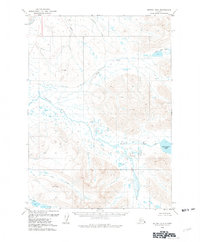
1979 Map of Bethel B-2
USGS Topo · Published 1979About this map
Kisaralik River and its complex network of tributaries dominate this Southwest Alaska landscape during the late 1970s. The map illustrates a wilderness defined by water and elevation, where the river winds past significant terrain features like Silver and Gravel. To the east, the expansive Kisaralik Lake serves as a major focal point, fed by and feeding into the surrounding drainage systems.
Find a feature on this map
13 named features on this map. Tap any name to fly to it.
Don’t see what you’re looking for? This feature index may not catch every label — zoom into the map to look around manually.
Map Details
Editions of this 1979 Bethel B-2 Map
2 editions found
Other maps of this area

1950 · Bethel
USGS Topo · 1:250,000

1954 · Bethel C-3
USGS Topo · 1:63,360

1954 · Bethel B-3
USGS Topo · 1:63,360

1979 · Bethel B-1
USGS Topo · 1:63,360

1979 · Bethel A-3
USGS Topo · 1:63,360

1979 · Bethel A-1
USGS Topo · 1:63,360

1979 · Bethel A-2
USGS Topo · 1:63,360

1979 · Bethel C-2
USGS Topo · 1:63,360

1979 · Bethel B-2
USGS Topo · 1:63,360
1979 · Bethel C-1
USGS Topo · 1:63,360