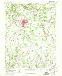
1968 Map of Bethel
USGS Topo · Published 1970About this map
Bethel serves as the central hub for this portion of Clermont County, centered at the intersection of several regional routes and the Bethel Reservoir. The village is well-established with civic landmarks including the Auditorium, Fire Sta, and Bethel-Tate High Sch. Beyond the village limits, the landscape transitions into a network of rural hamlets and family-named landmarks. Smaller settlements like Wiggonsville, Yankeetown, and Maple are connected by a dense web of local roads such as Swings Corner Road and Pitzer Road. The terrain is deeply etched by a complex drainage system featuring Cloverlick Creek and Indian Creek, which dictates the placement of outlying sites like the Bethlehem Tabernacle and Lakin Chapel. Genealogical researchers will find significant detail in the numerous rural burial grounds, including Rose Hill Cem and Brooks Cem, which anchor the smaller crossroads communities.
Find a feature on this map
91 named features on this map. Tap any name to fly to it.
Don’t see what you’re looking for? This feature index may not catch every label — zoom into the map to look around manually.
Map Details
Editions of this 1968 Bethel Map
4 editions found
Other maps of this area

1914 · Batavia
USGS Topo · 1:48,000

1916 · Batavia
USGS Topo · 1:62,500

1917 · Sardinia
USGS Topo · 1:62,500

1928 · Higginsport
USGS Topo · 1:48,000

1931 · Felicity
USGS Topo · 1:62,500

1931 · Higginsport
USGS Topo · 1:62,500

1944 · Sardinia
USGS Topo · 1:62,500

1947 · Columbus
USGS Topo · 1:250,000

1952 · Higginsport
USGS Topo · 1:24,000

1953 · Laurel
USGS Topo · 1:24,000