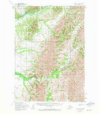
1954 Map of Bethel D-3
USGS Topo · Published 1973About this map
The Kilbuck Mountains dominate this 1950s interior landscape, where the Tuluksak River and its numerous tributaries carve through the upland terrain. In the northern reaches of the quadrangle, Nyac Airfield appears as a critical remote transportation link near the headwaters of Granite Creek and Mary Lou Gulch. The complex drainage network is defined by several prominent watercourses including Otter Creek, Slate Creek, and the southern Fog River. Rising above the valley floors, Fisher Dome serves as a distinct topographical landmark in the eastern section of the survey. The mapping reveals a territory largely defined by its natural water systems and high-altitude features, reflecting the era's focus on documenting the remote Kuskokwim region for resource management and navigation.
Find a feature on this map
12 named features on this map. Tap any name to fly to it.
Don’t see what you’re looking for? This feature index may not catch every label — zoom into the map to look around manually.
Map Details
Editions of this 1954 Bethel D-3 Map
2 editions found
Other maps of this area

1947 · Russian Mission
USGS Topo · 1:250,000

1950 · Russian Mission
USGS Topo · 1:250,000

1950 · Bethel
USGS Topo · 1:250,000

1954 · Russian Mission A-4
USGS Topo · 1:63,360

1954 · Bethel D-4
USGS Topo · 1:63,360

1954 · Bethel C-4
USGS Topo · 1:63,360

1954 · Bethel C-3
USGS Topo · 1:63,360

1954 · Russian Mission A-3
USGS Topo · 1:63,360

1954 · Bethel D-3
USGS Topo · 1:63,360

1979 · Bethel D-2
USGS Topo · 1:63,360