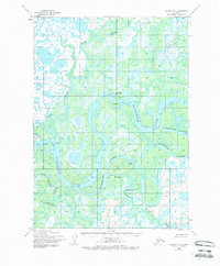
1954 Map of Bethel D-7
USGS Topo · Published 1972About this map
The Kuskokwim River dominates this landscape of the Yukon-Kuskokwim Delta, where a maze of interconnected waterways defines every aspect of movement and settlement. In the mid-1950s, the village of Akiachak sits prominently at a major bend, supported by a nearby Landing Strip and the natural harbor provided by Kiktak Is. The intricate network of secondary channels, including Kuskokuak Slough and Church Slough, reveals a complex hydraulic environment where Tidal Flats shift with the pulse of the Bering Sea tides.
Find a feature on this map
17 named features on this map. Tap any name to fly to it.
Don’t see what you’re looking for? This feature index may not catch every label — zoom into the map to look around manually.
Map Details
Editions of this 1954 Bethel D-7 Map
3 editions found
Other maps of this area

1947 · Russian Mission
USGS Topo · 1:250,000

1950 · Russian Mission
USGS Topo · 1:250,000

1950 · Bethel
USGS Topo · 1:250,000

1954 · Russian Mission A-6
USGS Topo · 1:63,360

1954 · Russian Mission A-8
USGS Topo · 1:63,360
1954 · Russian Mission A-7
USGS Topo · 1:63,360

1954 · Bethel D-8
USGS Topo · 1:63,360

1954 · Bethel C-6
USGS Topo · 1:63,360

1954 · Bethel D-7
USGS Topo · 1:63,360

1954 · Bethel D-6
USGS Topo · 1:63,360