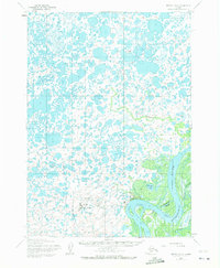
1954 Map of Bethel D-8
USGS Topo · Published 1972About this map
The Kuskokwim River dominates the landscape of this mid-century subarctic environment, defining the eastern edge of the community of Bethel. This period shows the town in transition, serving as a critical regional hub as evidenced by the dual presence of the Bethel Municipal Airport and the Bethel Airforce Station. The surrounding terrain is a complex network of wetlands and tundra, characterized by numerous small bodies of water and significant river features like Steamboat Slough and Church Slough.
Find a feature on this map
14 named features on this map. Tap any name to fly to it.
Don’t see what you’re looking for? This feature index may not catch every label — zoom into the map to look around manually.
Map Details
Editions of this 1954 Bethel D-8 Map
4 editions found
Other maps of this area

1947 · Russian Mission
USGS Topo · 1:250,000

1950 · Russian Mission
USGS Topo · 1:250,000

1950 · Bethel
USGS Topo · 1:250,000

1951 · Marshall
USGS Topo · 1:250,000

1951 · Baird Inlet
USGS Topo · 1:250,000

1954 · Russian Mission A-8
USGS Topo · 1:63,360
1954 · Russian Mission A-7
USGS Topo · 1:63,360

1954 · Marshall A-1
USGS Topo · 1:63,360

1954 · Bethel D-8
USGS Topo · 1:63,360

1954 · Bethel D-7
USGS Topo · 1:63,360