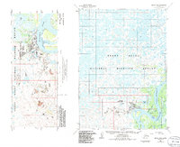
1954 Map of Bethel D-8
USGS Topo · Published 1986About this map
Bethel serves as the central hub of activity along the sprawling Kuskokwim River, a landscape defined by an intricate network of waterways including Steamboat Slough and Church Slough. The community infrastructure is well-established, featuring the Mikelnguut Elitnaurviat Sch, Bethel High Sch, and the Kuskokwim Community College, alongside critical services like the Hosp and Municipal Airport.
Find a feature on this map
28 named features on this map. Tap any name to fly to it.
Don’t see what you’re looking for? This feature index may not catch every label — zoom into the map to look around manually.
Map Details
Editions of this 1954 Bethel D-8 Map
4 editions found
Other maps of this area

1947 · Russian Mission
USGS Topo · 1:250,000

1950 · Russian Mission
USGS Topo · 1:250,000

1950 · Bethel
USGS Topo · 1:250,000

1951 · Marshall
USGS Topo · 1:250,000

1951 · Baird Inlet
USGS Topo · 1:250,000

1954 · Russian Mission A-8
USGS Topo · 1:63,360
1954 · Russian Mission A-7
USGS Topo · 1:63,360

1954 · Marshall A-1
USGS Topo · 1:63,360

1954 · Bethel D-8
USGS Topo · 1:63,360

1954 · Bethel D-7
USGS Topo · 1:63,360