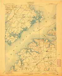
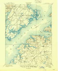
1900 Map of Betterton
USGS Topo · Published 1907About this map
The Chesapeake Bay dominates this late nineteenth-century maritime landscape, serving as the central artery between the shores of Harford and Kent Counties. This survey captures a period of intense coastal activity before the modern era, evidenced by numerous landing points and maritime aids such as the Fishing Battery L.H. and the light at Elk Neck. On the southern shore, Stillpond Neck and Worton district are punctuated by commercial hubs like Harris Wharf and Green Point Whf., which facilitated the movement of goods from inland agricultural communities like Stillpond and Coleman. Across the water, Spesutie Island sits adjacent to the Phila. Balto. and Wash. R.R., which connected small trackside settlements such as Perryman and Belcamp. The map preserves the layout of rural districts like Halls Crossroads, documenting the location of local schools, churches, and family-named landings such as Buck Neck Landing along the tidal inlets.
Find a feature on this map
84 named features on this map. Tap any name to fly to it.
Don’t see what you’re looking for? This feature index may not catch every label — zoom into the map to look around manually.
Map Details
Editions of this 1900 Betterton Map
6 editions found
Other maps of this area

1893 · North Point
USGS Topo · 1:62,500

1893 · Gunpowder
USGS Topo · 1:62,500

1898 · Elkton
USGS Topo · 1:62,500

1898 · Tolchester
USGS Topo · 1:125,000

1899 · Dover
USGS Topo · 1:125,000

1900 · Elkton
USGS Topo · 1:62,500

1900 · Cecilton
USGS Topo · 1:62,500

1900 · Havre De Grace
USGS Topo · 1:62,500

1900 · Betterton
USGS Topo · 1:62,500

1901 · Belair
USGS Topo · 1:62,500