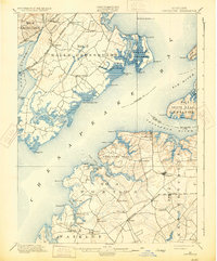
1900 Map of Betterton
USGS Topo · Published 1931About this map
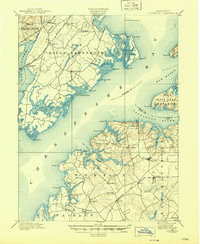
The Upper Chesapeake Bay at the turn of the century reveals a landscape defined by its deep necks and intricate water connections. On the eastern shore of the bay, settlements such as Betterton and Stillpond serve as hubs for the surrounding agricultural districts, while the western shore is dominated by the Bush River and the military and maritime operations near Spesutie Island. The prominence of steamship landings and wharves, such as Harris Wharf and Green Point Whf., underscores a period when the bay's tributaries remained primary thoroughfares for commerce and travel before the total dominance of overland routes.
Find a feature on this map
79 named features on this map. Tap any name to fly to it.
Don’t see what you’re looking for? This feature index may not catch every label — zoom into the map to look around manually.
Map Details
Editions of this 1900 Betterton Map
6 editions found
Other maps of this area

1893 · North Point
USGS Topo · 1:62,500

1893 · Gunpowder
USGS Topo · 1:62,500

1898 · Elkton
USGS Topo · 1:62,500

1898 · Tolchester
USGS Topo · 1:125,000

1899 · Dover
USGS Topo · 1:125,000

1900 · Elkton
USGS Topo · 1:62,500

1900 · Cecilton
USGS Topo · 1:62,500

1900 · Havre De Grace
USGS Topo · 1:62,500

1900 · Betterton
USGS Topo · 1:62,500

1901 · Belair
USGS Topo · 1:62,500