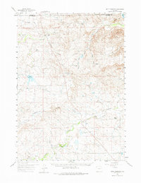
1959 Map of Betty Reservoir
USGS Topo · Published 1975About this map
The Cheyenne River and its western tributaries define this high plains landscape on the border of Campbell and Converse Counties. At the center of the survey lies the ranching settlement of Verse, while the nearby Old Verse (Site) points to the shifting locations of early rural post offices and homesteads. The water infrastructure of the era is evident in the Betty Reservoir and the accompanying Betty Supply Ditch, critical for sustaining livestock and agriculture in this semi-arid region.
Find a feature on this map
30 named features on this map. Tap any name to fly to it.
Don’t see what you’re looking for? This feature index may not catch every label — zoom into the map to look around manually.
Map Details
Editions of this 1959 Betty Reservoir Map
2 editions found
Other maps of this area

1955 · Newcastle
USGS Topo · 1:250,000

1958 · Newcastle
USGS Topo · 1:250,000

1959 · Bill
USGS Topo · 1:62,500

1959 · Betty Reservoir
USGS Topo · 1:62,500

1959 · Coal Draw
USGS Topo · 1:62,500
1959 · Highland Flats
USGS Topo · 1:62,500

1960 · Turnercrest
USGS Topo · 1:62,500

1970 · Bill 4 NW
USGS Topo · 1:24,000

1971 · Coal Bank Draw
USGS Topo · 1:24,000

1971 · Teckla
USGS Topo · 1:24,000