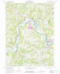
1961 Map of Beverly
USGS Topo · Published 1991About this map
The Muskingum River dominates this portion of southeastern Ohio, carving a winding path between Beverly and Waterford. This 1961 survey, updated through the mid-1970s and 1980s, highlights the river's role as a primary artery for industry and transport, evidenced by the Baltimore and Ohio tracks and a large riverfront powerplant and Substation. To the north, the landscape transitions into a network of creek valleys and ridges, where small agricultural settlements like Mill Grove and Moscow Mills persist alongside numerous rural cemeteries. The map preserves the footprint of several smaller communities along the river bends, including Beckett, Luke Chute, and Swift, which were once vital stops for rail and river traffic. Genealogists will find a high density of family-named landmarks and rural burial grounds such as Milnor Cem and DeLong Cem scattered across the uplands of Windsor and Waterford townships.
Find a feature on this map
70 named features on this map. Tap any name to fly to it.
Don’t see what you’re looking for? This feature index may not catch every label — zoom into the map to look around manually.
Map Details
Editions of this 1961 Beverly Map
4 editions found
Other maps of this area

1902 · Parkersburg
USGS Topo · 1:62,500

1904 · Parkersburg
USGS Topo · 1:62,500

1904 · Chesterhill
USGS Topo · 1:62,500

1906 · Chesterhill
USGS Topo · 1:62,500

1909 · Caldwell
USGS Topo · 1:62,500

1910 · Mc Connelsville
USGS Topo · 1:62,500

1912 · Caldwell
USGS Topo · 1:62,500

1949 · Clarksburg
USGS Topo · 1:250,000

1956 · Clarksburg
USGS Topo · 1:250,000

1960 · Watertown
USGS Topo · 1:24,000