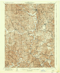
1908 Map of Bidwell
USGS Topo · Published 1936About this map
Vinton and Bidwell serve as key hubs in Gallia County during this early 20th-century survey, connected by the Hocking Valley RR which follows the winding path of Raccoon Creek. The landscape is a network of small, rural communities and post offices, including Centerville Thurman P.O. and Porter Pinegrove P.O.. This era reflects a highly localized society, evidenced by the high density of country schools like Tomato Valley School and Smoky Hollow School, and churches such as Nebo Church and Ebenezer Church. Infrastructure like Calhoun Bridge and Gee Bridge crosses the creek to link these upland settlements. The placement of Rio Grande and Patriot amidst the ridges of Huntington and Raccoon townships shows a settlement pattern dictated by the steep hollows and narrow valleys characteristic of the region.
Find a feature on this map
78 named features on this map. Tap any name to fly to it.
Don’t see what you’re looking for? This feature index may not catch every label — zoom into the map to look around manually.
Map Details
Editions of this 1908 Bidwell Map
2 editions found
Other maps of this area

1898 · Ironton
USGS Topo · 1:62,500

1900 · Ironton
USGS Topo · 1:62,500

1905 · Wilkesville
USGS Topo · 1:62,500

1906 · Bidwell
USGS Topo · 1:62,500

1906 · Athalia
USGS Topo · 1:62,500

1906 · Glenwood
USGS Topo · 1:62,500

1907 · Pomeroy
USGS Topo · 1:62,500

1908 · Bidwell
USGS Topo · 1:62,500

1908 · Athalia
USGS Topo · 1:62,500

1908 · Glenwood
USGS Topo · 1:62,500