
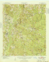
1949 Map of Bienville
USGS Topo · Published 1949About this map
Driskill Mountain rises as a prominent landmark in this upland portion of North Louisiana, overlooking a landscape defined by small rural settlements and a dense network of country churches and schools. The Louisiana and North West Railroad serves as the primary industrial corridor, connecting the town of Bienville with Bryceland and Bryce Sta. The terrain is deeply etched by the headwaters of the Dugdemona River and Saline Bayou, creating a patchwork of ridges and creek bottoms where family-named sites like Taylor Cem and Raspberry School reflect the community structure of the late 1940s.
Find a feature on this map
81 named features on this map. Tap any name to fly to it.
Don’t see what you’re looking for? This feature index may not catch every label — zoom into the map to look around manually.
Map Details
Editions of this 1949 Bienville Map
2 editions found
Other maps of this area

1947 · Goldonna
USGS Topo · 1:62,500

1947 · Ashland
USGS Topo · 1:62,500

1947 · Bienville
USGS Topo · 1:62,500

1948 · Jamestown
USGS Topo · 1:62,500

1949 · Jamestown
USGS Topo · 1:62,500

1949 · Jonesboro
USGS Topo · 1:62,500

1949 · Gibsland
USGS Topo · 1:62,500

1950 · Jonesboro
USGS Topo · 1:62,500

1950 · Gibsland
USGS Topo · 1:62,500

1950 · Ruston
USGS Topo · 1:62,500