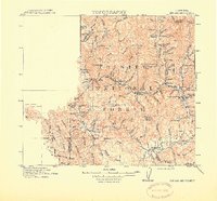
1915 Map of Big Bar and Vicinity
USGS Topo · Published 1915About this map
The Trinity River and its numerous glacial-carved tributaries dominate this 1915 study of the Klamath Mountains region. The landscape is defined by the early management of the Trinity National Forest, where small settlements like Big Bar and Helena served as vital hubs for the local mining and timber interests of the era. The mapping details a complex network of glacial features, including Rich Gl, Oregon Gl, and Noonan Gl, alongside rugged peaks such as Ironside Mtn and Hay Fork Baldy.
Find a feature on this map
99 named features on this map. Tap any name to fly to it.
Don’t see what you’re looking for? This feature index may not catch every label — zoom into the map to look around manually.
Map Details
Editions of this 1915 Big Bar and Vicinity Map
5 editions found
Other maps of this area

1886 · Shasta
USGS Topo · 1:250,000

1890 · Red Bluff
USGS Topo · 1:250,000

1894 · Red Bluff
USGS Topo · 1:250,000

1894 · Shasta
USGS Topo · 1:250,000

1909 · Big Bar
USGS Topo · 1:96,000

1913 · Weaverville
USGS Topo · 1:125,000

1914 · Pilot Creek
USGS Topo · 1:62,500

1915 · Big Bar and Vicinity
USGS Topo · 1:250,000

1918 · Anada
USGS Topo · 1:62,500

1921 · Dyerville
USGS Topo · 1:62,500