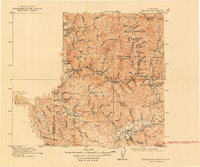
1915 Map of Big Bar and Vicinity
USGS Topo · Published 1948About this map
Trinity National Forest defines this early 20th-century landscape, capturing a rugged interior of Northern California before modern highway systems reshaped access. The terrain is marked by deep canyons and high ridges, where the Trinity River and Hay Fork provide the primary corridors for settlement. Small outposts such as Hyampom and Burnt Ranch are shown in their early development, while the mining influence is evident in the cluster of locations near the eastern boundary, including Dedrick and Canyon City. The map documents a time when movement through the mountains relied on landmarks like Waldorf Crossing and Natural Bridge. The presence of numerous camps and flats, such as Stove Camp and Cedar Flat, reflects a landscape utilized by foresters, ranchers, and prospectors navigating the steep slopes between South Fork Mountain and the Limestone Ridge.
Find a feature on this map
96 named features on this map. Tap any name to fly to it.
Don’t see what you’re looking for? This feature index may not catch every label — zoom into the map to look around manually.
Map Details
Editions of this 1915 Big Bar and Vicinity Map
5 editions found
Other maps of this area

1886 · Shasta
USGS Topo · 1:250,000

1890 · Red Bluff
USGS Topo · 1:250,000

1894 · Red Bluff
USGS Topo · 1:250,000

1894 · Shasta
USGS Topo · 1:250,000

1909 · Big Bar
USGS Topo · 1:96,000

1913 · Weaverville
USGS Topo · 1:125,000

1914 · Pilot Creek
USGS Topo · 1:62,500

1915 · Big Bar and Vicinity
USGS Topo · 1:250,000

1918 · Anada
USGS Topo · 1:62,500

1921 · Dyerville
USGS Topo · 1:62,500