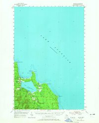
1954 Map of Big Bay
USGS Topo · Published 1965About this map
Lake Superior dominates the northern horizon of this Marquette County shoreline, where the community of Big Bay sits at the intersection of maritime and timber interests. The map illustrates a landscape of transitional coastal features, from the sandy stretch of Squaw Beach to the prominent navigational beacon at Lighthouse on Big Bay Point. Inland, the freshwater expanse of Lake Independence is regulated by Spillway 626, reflecting mid-century water management efforts. The vast Escanaba River State Forest covers the southern terrain, interspersed with small settlements and resource-based outposts like Antlers, Homeier, and a Gravel Pit. Notable social and industrial landmarks including the Community Ch and the Bay Cliff Health Camp indicate the dual role of the region as both a working landscape and a remote retreat for health and recreation.
Find a feature on this map
28 named features on this map. Tap any name to fly to it.
Don’t see what you’re looking for? This feature index may not catch every label — zoom into the map to look around manually.
Map Details
Editions of this 1954 Big Bay Map
3 editions found
Other maps of this area

1907 · Marquette
USGS Topo · 1:62,500

1953 · Marquette NW
USGS Topo · 1:24,000

1954 · Negaunee
USGS Topo · 1:62,500

1954 · Huron Mountain
USGS Topo · 1:62,500

1954 · Big Bay
USGS Topo · 1:62,500

1954 · Marquette
USGS Topo · 1:62,500

1955 · Champion
USGS Topo · 1:62,500

1958 · Hancock
USGS Topo · 1:250,000

1958 · Marquette
USGS Topo · 1:250,000

1960 · Hancock
USGS Topo · 1:250,000