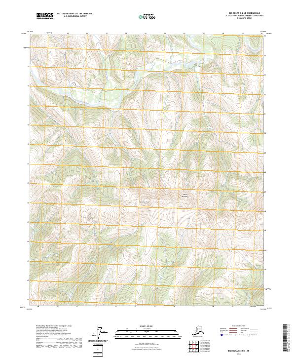
2024 Map of Big Delta B-2 NE
USGS Topo · Published 2024About this map
Goodpaster River winds through this interior Alaskan wilderness, following a low-elevation valley that cuts across the northern half of the landscape. The river serves as the primary drainage for several smaller tributaries, including the northern-flowing Glacier Creek and Samara Creek further west. This 2024 survey captures the high-elevation terrain of the Mertie Mountains, which dominate the central and eastern portions of the quadrangle. The highest point shown is Shawnee Peak, a prominent landmark that defines the local topography. This area remains largely undeveloped, defined by its complex drainage patterns and elevation changes rather than human settlement or infrastructure. The map provides a detailed view of the natural hydrology and land divisions, including the boundaries of t5s r15e and t6s r16e, which organize this vast stretch of the Southeast Fairbanks Census Area.
Find a feature on this map
9 named features on this map. Tap any name to fly to it.
Don’t see what you’re looking for? This feature index may not catch every label — zoom into the map to look around manually.
Map Details
Editions of this 2024 Big Delta B-2 NE Map
This is the sole edition of this map. No revisions or reprints were ever made.
Other maps of this area

1950 · Big Delta
USGS Topo · 1:250,000

1951 · Big Delta
USGS Topo · 1:250,000

1958 · Big Delta B-2
USGS Topo · 1:63,360

1958 · Big Delta B-1
USGS Topo · 1:63,360

1958 · Big Delta C-2
USGS Topo · 1:63,360

1958 · Big Delta C-1
USGS Topo · 1:63,360

1958 · Big Delta
USGS Topo · 1:250,000
2018 · Big Delta B-1 SW
USGS Topo · 1:25,000
2018 · Big Delta B-2 SE
USGS Topo · 1:25,000
2018 · Big Delta C-2 SE
USGS Topo · 1:25,000