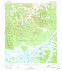
1950 Map of Big Delta B-4
USGS Topo · Published 1972About this map
Shaw Creek Flats dominate the southern portion of this interior landscape, where a complex network of wetlands and meandering waterways defines the drainage patterns of the Fairbanks North Star Borough. The contrast between these low-lying marshlands and the rising elevations to the north is sharp, with numerous survey points such as VABM 4084 Mid and VABM 3570 Peak marking the high ridges. This 1950s data reveals a wilderness environment structured by the courses of Gilles Creek, Caribou Creek, and the South Fork Salcha River. The lack of roads or established settlements emphasizes the reliance on natural drainages like Cottonwood Creek and Flat Creek for navigation and orientation. Small tributaries such as Corda Cr and Rapid Creek feed into the broader basin, providing a detailed look at the watershed before modern development reached this section of the Alaskan interior.
Find a feature on this map
18 named features on this map. Tap any name to fly to it.
Don’t see what you’re looking for? This feature index may not catch every label — zoom into the map to look around manually.
Map Details
Editions of this 1950 Big Delta B-4 Map
4 editions found
Other maps of this area

1949 · Big Delta B-5
USGS Topo · 1:63,360

1950 · Big Delta
USGS Topo · 1:250,000

1950 · Big Delta A-5
USGS Topo · 1:63,360

1950 · Big Delta A-4
USGS Topo · 1:63,360

1950 · Big Delta B-4
USGS Topo · 1:63,360

1951 · Big Delta
USGS Topo · 1:250,000

1952 · Big Delta A-5
USGS Topo · 1:63,360

1952 · Big Delta A-4
USGS Topo · 1:63,360

1952 · Big Delta B-5
USGS Topo · 1:63,360

1953 · Big Delta B-4
USGS Topo · 1:63,360