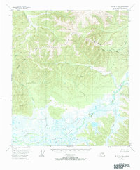
1950 Map of Big Delta B-4
USGS Topo · Published 1984About this map
Shaw Creek Flats dominates the southern reaches of this interior Alaskan landscape, forming a complex network of wetlands and braided drainage systems. Based on 1950 aerial photography, the map reveals a rugged terrain where the Fairbanks North Star Borough boundary cuts across high ridges and deep valleys. Several prominent vertical angle bench marks, including Vabm 4084 and VABM 3570 Peak, indicate the significant elevation changes that define the watershed between the Salcha River and Shaw Creek. The drainage patterns, from the narrow canyons of Gilles Creek to the broader meandering path of Caribou Creek, suggest a wilderness largely untouched by formal road networks at mid-century. This survey provides a baseline for understanding the hydrologic and topographic character of the region before modern development or significant shifts in the permafrost landscape altered the surface features of the flats.
Find a feature on this map
17 named features on this map. Tap any name to fly to it.
Don’t see what you’re looking for? This feature index may not catch every label — zoom into the map to look around manually.
Map Details
Editions of this 1950 Big Delta B-4 Map
4 editions found
Other maps of this area

1949 · Big Delta B-5
USGS Topo · 1:63,360

1950 · Big Delta
USGS Topo · 1:250,000

1950 · Big Delta A-5
USGS Topo · 1:63,360

1950 · Big Delta A-4
USGS Topo · 1:63,360

1950 · Big Delta B-4
USGS Topo · 1:63,360

1951 · Big Delta
USGS Topo · 1:250,000

1952 · Big Delta A-5
USGS Topo · 1:63,360

1952 · Big Delta A-4
USGS Topo · 1:63,360

1952 · Big Delta B-5
USGS Topo · 1:63,360

1953 · Big Delta B-4
USGS Topo · 1:63,360