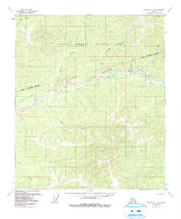
1958 Map of Big Delta C-4
USGS Topo · Published 1991About this map
The Salcha River dominates the central portion of this landscape, carving a wide valley through the interior Alaskan wilderness. During the mid-twentieth century, this region served a critical military role as the Yukon Command Training Site, defined by a prominent Military Reservation Boundary that bisects the terrain. Settlement is sparse and focused on survival and transport, marked by a remote Cabin and the small outpost of Caribou near a strategic Landing Strip. This survey provides a record of the logistics required for cold-weather operations, showing a network of a Tractor Trail crossing through the hills between Butte Creek and Caribou Creek. To the north, the headwaters of the Chena River appear, while various smaller tributaries like No Grub Creek and Bullfrog Cr drain the uplands into the larger river systems.
Find a feature on this map
17 named features on this map. Tap any name to fly to it.
Don’t see what you’re looking for? This feature index may not catch every label — zoom into the map to look around manually.
Map Details
Editions of this 1958 Big Delta C-4 Map
3 editions found
Other maps of this area

1949 · Big Delta B-5
USGS Topo · 1:63,360

1950 · Big Delta
USGS Topo · 1:250,000

1950 · Big Delta B-4
USGS Topo · 1:63,360

1951 · Big Delta
USGS Topo · 1:250,000

1952 · Big Delta B-5
USGS Topo · 1:63,360

1953 · Big Delta B-4
USGS Topo · 1:63,360

1958 · Big Delta C-5
USGS Topo · 1:63,360

1958 · Big Delta D-5
USGS Topo · 1:63,360

1958 · Big Delta C-4
USGS Topo · 1:63,360

1958 · Big Delta D-4
USGS Topo · 1:63,360