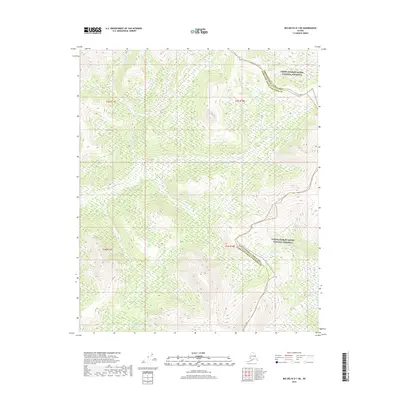
2018 Map of Big Delta D-1 NE
USGS Topo · Published 2018About this map
The Yukon-Charley Rivers National Preserve encompasses the northeast corner of this territory, where the interior wilderness meets the Fairbanks North Star Borough boundary. This high-latitude landscape is defined by its drainages, notably Cottonwood Cr flowing through the northwestern reaches and Lost Cr cutting across the central hills. To the south, Serpentine Cr winds through the base of the terrain, illustrating the complex hydrology of the Alaska interior. This 2018 survey detail provides a clear record of the watershed patterns and topography within this protected federal land, where traditional land divisions such as t2n r18e and t1n r17e segment the uninhabited expanse of the Unorganized Borough.
Find a feature on this map
9 named features on this map. Tap any name to fly to it.
Don’t see what you’re looking for? This feature index may not catch every label — zoom into the map to look around manually.
Map Details
Editions of this 2018 Big Delta D-1 NE Map
This is the sole edition of this map. No revisions or reprints were ever made.
Other maps of this area

1950 · Big Delta
USGS Topo · 1:250,000

1951 · Big Delta
USGS Topo · 1:250,000

1951 · Charley River
USGS Topo · 1:250,000

1951 · Eagle
USGS Topo · 1:250,000

1951 · Circle
USGS Topo · 1:250,000

1955 · Circle A-1
USGS Topo · 1:63,360

1955 · Circle
USGS Topo · 1:250,000

1956 · Charley River A-6
USGS Topo · 1:63,360

1956 · Charley River
USGS Topo · 1:250,000
1956 · Eagle D-6
USGS Topo · 1:63,360